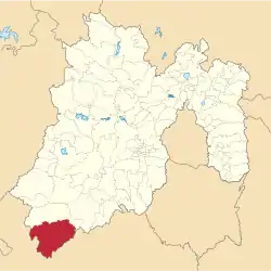
Municipio Tlatlaya
| Tlatlaya | ||
|---|---|---|
 | ||
| Symbole | ||
| ||
| Basisdaten | ||
| Staat | Mexiko | |
| Bundesstaat | México | |
| Sitz | Tlatlaya | |
| Fläche | 790,1 km² | |
| Einwohner | 32.997 (2010) | |
| Dichte | 41,8 Einwohner pro km² | |
| Gründung | 1849 | |
| INEGI-Nr. | 15105 | |
| Politik | ||
| Presidente municipal | Ariel Mora Abarca | |
Tlatlaya ist ein Municipio im mexikanischen Bundesstaat México. Das Municipio hatte beim Zensus 2010 32997 Einwohner, die Fläche beläuft sich auf 798,92 km². Der Sitz der Gemeinde ist das gleichnamige Tlatlaya, die größten der 165 Orte des Municipios sind hingegen San Pedro Limón und Santa Ana Zicatecoyan.
Geographie
Tlatlaya liegt im äußersten Südwesten des Bundesstaates México, etwa 120 km südwestlich von Toluca de Lerdo auf einer Höhe von 300 m bis 2400 m.
Das Municipio Tlatlaya grenzt ans Municipio Amatepec, sowie an den Bundesstaat Guerrero.
Weblinks
- Enciclopedia de los Municipios y Delegaciones de México: Municipio Tlatlaya (spanisch)
- INEGI: Datos Geográficos: Municipio Tlatlaya (spanisch; PDF)
This article is issued from Wikipedia. The text is licensed under Creative Commons - Attribution - Sharealike. The authors of the article are listed here. Additional terms may apply for the media files, click on images to show image meta data.

