Municipio Ayapango
| Ayapango | ||
|---|---|---|
 | ||
| Symbole | ||
| ||
| Basisdaten | ||
| Staat | Mexiko | |
| Bundesstaat | México | |
| Sitz | Ayapango de Gabriel Ramos Millán | |
| Fläche | 36,6 km² | |
| Einwohner | 8864 (2010) | |
| Dichte | 242,5 Einwohner pro km² | |
| Gründung | 1868 | |
| Webauftritt | www.ayapango.gob.mx/ | |
| INEGI-Nr. | 15017 | |
| Politik | ||
| Presidente municipal | Pedro Alfonso Sánchez Solares | |
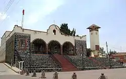 Municipalpalast von Ayapango | ||

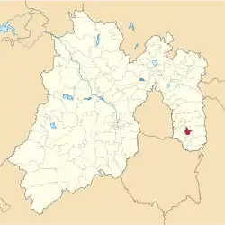
Ayapango ist ein Municipio im mexikanischen Bundesstaat México. Es gehört zur Zona Metropolitana del Valle de México, der Metropolregion um Mexiko-Stadt. Der Sitz der Gemeinde und deren größter Ort ist Ayapango de Gabriel Ramos Millán. Die Gemeinde hatte im Jahr 2010 8.864 Einwohner, ihre Fläche beträgt 36,6 km².
Geographie
Acolman liegt im Südosten des Bundesstaates México.
Das Municipio grenzt an die Municipios Tenango del Aire, Tlalmanalco, Amecameca und Juchitepec.
Weblinks
- Enciclopedia de los Municipios y Delegaciones de México: Municipio Ayapango (spanisch)
- INEGI: Datos Geográficos: Municipio Ayapango (spanisch; PDF)

Acambay | Acolman | Aculco | Almoloya de Alquisiras | Almoloya de Juárez | Almoloya del Río | Amanalco | Amatepec | Amecameca | Apaxco | Atenco | Atizapán | Atizapán de Zaragoza | Atlacomulco | Atlautla | Axapusco | Ayapango | Calimaya | Capulhuac | Chalco | Chapa de Mota | Chapultepec | Chiautla | Chicoloapan | Chiconcuac | Chimalhuacán | Coacalco de Berriozábal | Coatepec Harinas | Cocotitlán | Coyotepec | Cuautitlán | Cuautitlán Izcalli | Donato Guerra | Ecatepec de Morelos | Ecatzingo | El Oro | Huehuetoca | Hueypoxtla | Huixquilucan | Isidro Fabela | Ixtapaluca | Ixtapan de la Sal | Ixtapan del Oro | Ixtlahuaca | Jaltenco | Jilotepec | Jilotzingo | Jiquipilco | Jocotitlán | Joquicingo | Juchitepec | La Paz | Lerma | Luvianos | Malinalco | Melchor Ocampo | Metepec | Mexicaltzingo | Morelos | Naucalpan de Juárez | Nextlalpan | Nezahualcóyotl | Nicolás Romero | Nopaltepec | Ocoyoacac | Ocuilan | Otumba | Otzoloapan | Otzolotepec | Ozumba | Papalotla | Polotitlán | Rayón | San Antonio la Isla | San Felipe del Progreso | San José del Rincón | San Martín de las Pirámides | San Mateo Atenco | San Simón de Guerrero | Santo Tomás | Soyaniquilpan de Juárez | Sultepec | Tecámac | Tejupilco | Temamatla | Temascalapa | Temascalcingo | Temascaltepec | Temoaya | Tenancingo | Tenango del Aire | Tenango del Valle | Teoloyucan | Teotihuacán | Tepetlaoxtoc | Tepetlixpa | Tepotzotlán | Tequixquiac | Texcaltitlán | Texcalyacac | Texcoco | Tezoyuca | Tianguistenco | Timilpan | Tlalmanalco | Tlalnepantla de Baz | Tlatlaya | Toluca | Tonanitla | Tonatico | Tultepec | Tultitlán | Valle de Bravo | Valle de Chalco Solidaridad | Villa de Allende | Villa del Carbón | Villa Guerrero | Villa Victoria | Xalatlaco | Xonacatlán | Zacazonapan | Zacualpan | Zinacantepec | Zumpahuacán | Zumpango