Municipio Cocotitlán
| Cocotitlán | ||
|---|---|---|
 | ||
| Symbole | ||
| ||
| Basisdaten | ||
| Staat | Mexiko | |
| Bundesstaat | México | |
| Sitz | Cocotitlán | |
| Fläche | 15 km² | |
| Einwohner | 12.142 (2010) | |
| Dichte | 809,3 Einwohner pro km² | |
| Gründung | 1868 | |
| Webauftritt | cocotitlan.gob.mx | |
| INEGI-Nr. | 15022 | |
| Politik | ||
| Presidente municipal | Miguel Florín González | |
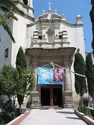
 Templo la Purísima Concepción in Cocotitlán | ||
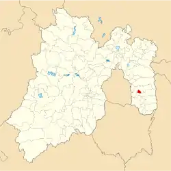
Cocotitlán ist ein Municipio im mexikanischen Bundesstaat México. Es gehört zur Zona Metropolitana del Valle de México, der Metropolregion um Mexiko-Stadt. Die Gemeinde hatte im Jahr 2010 12.142 Einwohner, ihre Fläche beträgt 15 km².

Cocotitlán
Verwaltungssitz und größter Ort des Municipios ist das gleichnamige Cocotitlán, die nächstgrößeren Orte sind San Andrés Metla und Ejido Atoyac.
Geographie
Das Municipio Cocotitlán liegt im Osten des Bundesstaats México. Es grenzt an die Municipios Chalco, Tlalmanalco und Temamatla.
Weblinks
Commons: Cocotitlán Municipality – Sammlung von Bildern, Videos und Audiodateien
- Enciclopedia de los Municipios y Delegaciones de México: Municipio Cocotitlán (spanisch)
- INEGI: Datos Geográficos: Municipio Cocotitlán (spanisch; PDF)
This article is issued from Wikipedia. The text is licensed under Creative Commons - Attribution - Sharealike. The authors of the article are listed here. Additional terms may apply for the media files, click on images to show image meta data.

