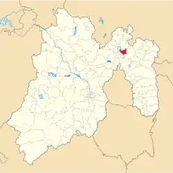
Municipio Nextlalpan
| Nextlalpan | ||
|---|---|---|
 | ||
| Symbole | ||
| ||
| Basisdaten | ||
| Staat | Mexiko | |
| Bundesstaat | México | |
| Sitz | Santa Ana Nextlalpan | |
| Fläche | 54,7 km² | |
| Einwohner | 34.374 (2010) | |
| Dichte | 628 Einwohner pro km² | |
| Gründung | 1820 | |
| INEGI-Nr. | 15059 | |
| Politik | ||
| Presidente municipal | Sergio Juárez Briones | |
.JPG.webp) Santa Ana Nextlalpan | ||
Nextlalpan ist ein Municipio im mexikanischen Bundesstaat México. Es gehört zur Zona Metropolitana del Valle de México, der Metropolregion um Mexiko-Stadt.
Das Municipio hatte im Jahr 2010 34.374 Einwohner, seine Fläche beträgt 54,7 km². Verwaltungssitz des Municipios und größter dessen 34 Orte ist Santa Ana Nextlalpan. Weitere größere Orte sind Ex-Hacienda Santa Inés, San Miguel Jaltocan und Prados San Francisco.
Geographie
Nextlalpan liegt im Norden des Bundesstaates Mexiko, etwa 30 km nordöstlich von Mexiko-Stadt auf etwa 2200 m Höhe. Etwa 80 % der Fläche des Municipios werden landwirtschaftlich genutzt.
Das Municipio Nextlalpan grenzt an die Municipios Zumpango, Jaltenco, Tecámac, Tonanitla, Tultitlán, Tultepec, Melchor Ocampo und Teoloyucan.
Weblinks
Commons: Nextlalpan – Sammlung von Bildern, Videos und Audiodateien
- Enciclopedia de los Municipios y Delegaciones de México: Municipio Nextlalpan (spanisch)
- INEGI: Datos Geográficos: Municipio Nextlalpan (spanisch; PDF)
This article is issued from Wikipedia. The text is licensed under Creative Commons - Attribution - Sharealike. The authors of the article are listed here. Additional terms may apply for the media files, click on images to show image meta data.

