Marcilly-sur-Tille
Marcilly-sur-Tille ist eine französische Gemeinde mit 1.688 Einwohnern (Stand: 1. Januar 2019) im Département Côte-d’Or in der Region Bourgogne-Franche-Comté. Sie gehört zum Arrondissement Dijon und zum Kanton Is-sur-Tille. Die Einwohner werden Marciliens genannt.
| Marcilly-sur-Tille | ||
|---|---|---|
| ||
| Staat | Frankreich | |
| Region | Bourgogne-Franche-Comté | |
| Département (Nr.) | Côte-d’Or (21) | |
| Arrondissement | Dijon | |
| Kanton | Is-sur-Tille | |
| Gemeindeverband | Vallées de la Tille et de l’Ignon | |
| Koordinaten | 47° 31′ N, 5° 8′ O | |
| Höhe | 213–317 m | |
| Fläche | 7,26 km² | |
| Einwohner | 1.688 (1. Januar 2019) | |
| Bevölkerungsdichte | 233 Einw./km² | |
| Postleitzahl | 21120 | |
| INSEE-Code | 21383 | |
| Website | https://www.marcillysurtille.fr/ | |
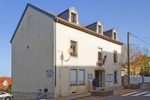 Rathaus (Mairie) von Marcilly-sur-Tille | ||

Geographie
Marcilly-sur-Tille liegt etwa 22 Kilometer nordnordöstlich von Dijon am Ignon und wird umgeben von Is-sur-Tille im Norden und Westen, Til-Châtel im Osten, Gemeaux im Süden sowie Chaignay im Südwesten.
Bevölkerungsentwicklung
| Jahr | 1962 | 1968 | 1975 | 1982 | 1990 | 1999 | 2006 | 2013 | |
| Einwohner | 790 | 733 | 1.209 | 1.350 | 1.403 | 1.432 | 1.485 | 1.684 | |
| Quellen: Cassini und INSEE | |||||||||
Sehenswürdigkeiten
- Kirche Saint-Jean-Claude aus dem 13. Jahrhundert
- Mühle aus dem 18. Jahrhundert
- Waschhaus
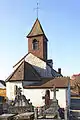 Kirche Saint-Jean-Claude
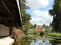 Waschhaus
This article is issued from Wikipedia. The text is licensed under Creative Commons - Attribution - Sharealike. The authors of the article are listed here. Additional terms may apply for the media files, click on images to show image meta data.