Larchant
Larchant ist eine französische Gemeinde mit 681 Einwohnern (Stand: 1. Januar 2019) im Département Seine-et-Marne in der Region Île-de-France. Sie gehört zum Arrondissement Fontainebleau und zum Kanton Nemours.
| Larchant | ||
|---|---|---|
| ||
| Staat | Frankreich | |
| Region | Île-de-France | |
| Département (Nr.) | Seine-et-Marne (77) | |
| Arrondissement | Fontainebleau | |
| Kanton | Nemours | |
| Gemeindeverband | Pays de Nemours | |
| Koordinaten | 48° 17′ N, 2° 36′ O | |
| Höhe | 62–141 m | |
| Fläche | 29,26 km² | |
| Einwohner | 681 (1. Januar 2019) | |
| Bevölkerungsdichte | 23 Einw./km² | |
| Postleitzahl | 77760 | |
| INSEE-Code | 77244 | |
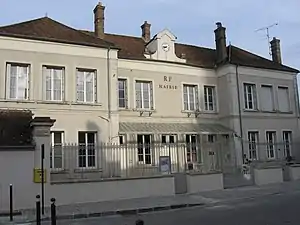 Mairie Larchant | ||

Lage
Die Gemeinde liegt im Regionalen Naturpark Gâtinais français.
| La Chapelle-la-Reine | Villiers-sous-Grez, Grez-sur-Loing | |
| Amponville | .svg.png.webp) |
Saint-Pierre-lès-Nemours |
| Guercheville | Chevrainvilliers |
Sehenswürdigkeiten
Siehe auch: Liste der Monuments historiques in Larchant
- Basilika Saint-Mathurin
- Bauernhof mit Taubenturm
- Grotte à la peinture, Höhlenmalereien
 Basilika Saint-Mathurin
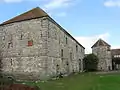 „Ferme du Chapitre“
Literatur
- Le Patrimoine des Communes de la Seine-et-Marne. Flohic Editions, Band 1, Paris 2001, ISBN 2-84234-100-7, S. 153–157.
This article is issued from Wikipedia. The text is licensed under Creative Commons - Attribution - Sharealike. The authors of the article are listed here. Additional terms may apply for the media files, click on images to show image meta data.