Chaintreaux
Chaintreaux ist eine französische Gemeinde mit 864 Einwohnern (Stand: 1. Januar 2019) im Département Seine-et-Marne in der Region Île-de-France. Sie gehört zum Arrondissement Fontainebleau und zum Kanton Nemours.
| Chaintreaux | ||
|---|---|---|
| ||
| Staat | Frankreich | |
| Region | Île-de-France | |
| Département (Nr.) | Seine-et-Marne (77) | |
| Arrondissement | Fontainebleau | |
| Kanton | Nemours | |
| Gemeindeverband | Gâtinais-Val de Loing | |
| Koordinaten | 48° 12′ N, 2° 49′ O | |
| Höhe | 88–133 m | |
| Fläche | 23,86 km² | |
| Einwohner | 864 (1. Januar 2019) | |
| Bevölkerungsdichte | 36 Einw./km² | |
| Postleitzahl | 77460 | |
| INSEE-Code | 77071 | |
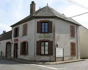 Mairie Chaintreaux | ||

Geographie
Chaintreaux liegt fünf Kilometer nordwestlich von Égreville und sieben Kilometer östlich von Souppes-sur-Loing.
| Poligny | Remauville | Lorrez-le-Bocage-Préaux |
| Souppes-sur-Loing | .svg.png.webp) |
Égreville |
| Dordives | Bransles |
Sehenswürdigkeiten
Siehe auch: Liste der Monuments historiques in Chaintreaux
- Kirche St. Peter-und-Paul
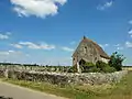 Kirche Saint-Eutrope im Ortsteil Lagerville
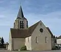 Kirche St. Peter-und-Paul
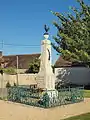 Kriegerdenkmal
Literatur
- Le Patrimoine des Communes de la Seine-et-Marne. Flohic Editions, Band 1, Paris 2001, ISBN 2-84234-100-7, S. 191–193.
Weblinks
Commons: Chaintreaux – Sammlung von Bildern, Videos und Audiodateien
- Chaintreaux bei annuaire-mairie.fr (französisch)
This article is issued from Wikipedia. The text is licensed under Creative Commons - Attribution - Sharealike. The authors of the article are listed here. Additional terms may apply for the media files, click on images to show image meta data.