Kanton Dourdan
Der Kanton Dourdan ist ein französischer Kanton (seit 2015) in den Arrondissements Étampes und Palaiseau (bis 2015: nur Arrondissement Ètampes), im Département Essonne und in der Region Île-de-France; sein Hauptort ist Dourdan. Vertreter im Generalrat des Départements ist seit 2004 Dominique Écharoux (UMP/LR) sowie seit 2015 Dany Boyer (DVD).
| Kanton Dourdan | |
|---|---|
| Region | Île-de-France |
| Département | Essonne |
| Arrondissement | Étampes Palaiseau |
| Hauptort | Dourdan |
| Einwohner | 66.282 (1. Jan. 2019) |
| Bevölkerungsdichte | 227 Einw./km² |
| Fläche | 291,61 km² |
| Gemeinden | 28 |
| INSEE-Code | 9105 |
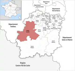 Lage des Kantons Dourdan im Département Essonne | |
Geographie
Der Kanton Dourdan liegt im Mittel 131 Meter über dem Meeresspiegel, zwischen 82 Meter in Roinville und 163 Meter in Dourdan.
Gemeinden
Der Kanton besteht aus 28 Gemeinden mit insgesamt 66.282 Einwohnern (Stand: 1. Januar 2019) auf einer Gesamtfläche von 291,61 km²:
| Gemeinde | Einwohner 1. Januar 2019 |
Fläche km² |
Dichte Einw./km² |
Code INSEE |
Postleitzahl | Arrondissement |
|---|---|---|---|---|---|---|
| Angervilliers | 1.723 | 9,12 | 189 | 91017 | 91470 | Palaiseau |
| Breuillet | 8.566 | 6,73 | 1.273 | 91105 | 91650 | Palaiseau |
| Breux-Jouy | 1.290 | 4,73 | 273 | 91106 | 91650 | Étampes |
| Briis-sous-Forges | 3.342 | 11,18 | 299 | 91111 | 91640 | Palaiseau |
| Chamarande | 1.133 | 5,83 | 194 | 91132 | 91730 | Étampes |
| Chauffour-lès-Étréchy | 137 | 4,84 | 28 | 91148 | 91580 | Étampes |
| Corbreuse | 1.718 | 15,85 | 108 | 91175 | 91410 | Étampes |
| Courson-Monteloup | 577 | 3,78 | 153 | 91186 | 91680 | Palaiseau |
| Dourdan | 10.452 | 30,72 | 340 | 91200 | 91410 | Étampes |
| Étréchy | 6.729 | 14,22 | 473 | 91226 | 91580 | Étampes |
| Fontenay-lès-Briis | 2.232 | 9,80 | 228 | 91243 | 91640 | Palaiseau |
| Forges-les-Bains | 3.923 | 14,67 | 267 | 91249 | 91470 | Palaiseau |
| Janvry | 635 | 8,35 | 76 | 91319 | 91640 | Palaiseau |
| La Forêt-le-Roi | 519 | 7,96 | 65 | 91247 | 91410 | Étampes |
| Les Granges-le-Roi | 1.177 | 12,82 | 92 | 91284 | 91410 | Étampes |
| Le Val-Saint-Germain | 1.486 | 12,65 | 117 | 91630 | 91530 | Étampes |
| Limours | 6.492 | 14,09 | 461 | 91338 | 91470 | Palaiseau |
| Mauchamps | 289 | 3,13 | 92 | 91378 | 91730 | Étampes |
| Richarville | 393 | 10,48 | 38 | 91519 | 91410 | Étampes |
| Roinville | 1.340 | 13,50 | 99 | 91525 | 91410 | Étampes |
| Saint-Chéron | 5.238 | 11,51 | 455 | 91540 | 91530 | Étampes |
| Saint-Cyr-sous-Dourdan | 937 | 10,08 | 93 | 91546 | 91410 | Étampes |
| Saint-Maurice-Montcouronne | 1.544 | 9,12 | 169 | 91568 | 91530 | Palaiseau |
| Saint-Sulpice-de-Favières | 278 | 4,41 | 63 | 91578 | 91910 | Étampes |
| Sermaise | 1.610 | 13,84 | 116 | 91593 | 91530 | Étampes |
| Souzy-la-Briche | 441 | 7,36 | 60 | 91602 | 91580 | Étampes |
| Vaugrigneuse | 1.355 | 6,16 | 220 | 91634 | 91640 | Palaiseau |
| Villeconin | 726 | 14,68 | 49 | 91662 | 91580 | Étampes |
| Kanton Dourdan | 66.282 | 291,61 | 227 | 9105 | – | – |
Der Kanton bestand bis zur landesweiten Neugliederung der Kantone 2015 aus elf Gemeinden auf einer Fläche von 138,39 km²: Authon-la-Plaine, Chatignonville, Corbreuse, Dourdan (Hauptort), La Forêt-le-Roi, Les Granges-le-Roi, Mérobert, Plessis-Saint-Benoist, Richarville, Roinville und Saint-Escobille.
Bevölkerungsentwicklung
| 1962 | 1968 | 1975 | 1982 | 1990 | 1999 | 2006 | 2011 |
|---|---|---|---|---|---|---|---|
| 6500 | 7825 | 10.444 | 12.330 | 14.138 | 15.176 | 15.872 | 16.707 |