Kanton Beuzeville
Der Kanton Beuzeville ist ein französischer Wahlkreis im Arrondissement Bernay, im Département Eure und in der Region Normandie; sein Hauptort ist Beuzeville. Vertreter im Generalrat des Départements sind seit 2015 Jean-Pierre Flambard (PS) und Micheline Paris (DVG).
| Kanton Beuzeville | |
|---|---|
| Region | Normandie |
| Département | Eure |
| Arrondissement | Bernay |
| Hauptort | Beuzeville |
| Einwohner | 31.915 (1. Jan. 2019) |
| Bevölkerungsdichte | 62 Einw./km² |
| Fläche | 518,37 km² |
| Gemeinden | 61 |
| INSEE-Code | 2703 |
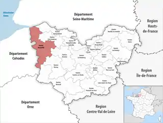 Lage des Kantons Beuzeville im Département Eure | |
Der Kanton Beuzeville ist 514,99 km² groß. Er liegt im Mittel auf 96 Meter über dem Meeresspiegel, zwischen 0 m in Berville-sur-Mer und 153 m in Vannecrocq.
Die Gemeinden im Kanton sind gemäß Erlass vom 31. Dezember 1997 Teil des Herkunftsgebietes Calvados. Der Kanton umfasst den nördlichen Teil des Hochplateaus Lieuvin.
Gemeinden
Der Kanton besteht aus 61 Gemeinden mit insgesamt 31.915 Einwohnern (Stand: 1. Januar 2019) auf einer Gesamtfläche von 518,37 km²:
| Gemeinde | Einwohner 1. Januar 2019 |
Fläche km² |
Dichte Einw./km² |
Code INSEE |
Postleitzahl |
|---|---|---|---|---|---|
| Asnières | 340 | 8,17 | 42 | 27021 | 27260 |
| Bailleul-la-Vallée | 102 | 4,71 | 22 | 27035 | 27260 |
| Barville | 78 | 2,68 | 29 | 27042 | 27230 |
| Bazoques | 149 | 6,91 | 22 | 27046 | 27230 |
| Berville-sur-Mer | 676 | 6,26 | 108 | 27064 | 27210 |
| Beuzeville | 4.666 | 23,29 | 200 | 27065 | 27210 |
| Boissy-Lamberville | 362 | 8,11 | 45 | 27079 | 27300 |
| Boulleville | 1.185 | 7,23 | 164 | 27100 | 27210 |
| Bournainville-Faverolles | 478 | 7,03 | 68 | 27106 | 27230 |
| Conteville | 1.010 | 10,68 | 95 | 27169 | 27210 |
| Cormeilles | 1.193 | 3,07 | 389 | 27170 | 27260 |
| Drucourt | 591 | 12,02 | 49 | 27207 | 27230 |
| Duranville | 151 | 4,76 | 32 | 27208 | 27230 |
| Épaignes | 1.580 | 26,33 | 60 | 27218 | 27260 |
| Épreville-en-Lieuvin | 198 | 6,74 | 29 | 27222 | 27560 |
| Fatouville-Grestain | 727 | 10,34 | 70 | 27233 | 27210 |
| Fiquefleur-Équainville | 739 | 9,65 | 77 | 27243 | 27210 |
| Folleville | 197 | 6,11 | 32 | 27248 | 27230 |
| Fontaine-la-Louvet | 328 | 11,06 | 30 | 27252 | 27230 |
| Fort-Moville | 522 | 9,35 | 56 | 27258 | 27210 |
| Foulbec | 663 | 11,83 | 56 | 27260 | 27210 |
| Fresne-Cauverville | 194 | 6,10 | 32 | 27269 | 27260 |
| Giverville | 409 | 6,19 | 66 | 27286 | 27560 |
| Heudreville-en-Lieuvin | 109 | 4,18 | 26 | 27334 | 27230 |
| La Chapelle-Bayvel | 375 | 4,97 | 75 | 27146 | 27260 |
| La Chapelle-Hareng | 113 | 4,10 | 28 | 27149 | 27230 |
| La Lande-Saint-Léger | 386 | 7,97 | 48 | 27361 | 27210 |
| La Noë-Poulain | 285 | 4,71 | 61 | 27435 | 27560 |
| La Poterie-Mathieu | 164 | 6,47 | 25 | 27475 | 27560 |
| Le Bois-Hellain | 215 | 3,18 | 68 | 27071 | 27260 |
| Le Favril | 166 | 4,08 | 41 | 27237 | 27230 |
| Le Mesnil-Saint-Jean | 220 | 7,90 | 28 | 27541 | 27560 |
| Le Planquay | 161 | 4,01 | 40 | 27462 | 27230 |
| Les Places | 73 | 1,98 | 37 | 27459 | 27230 |
| Le Theil-Nolent | 245 | 4,11 | 60 | 27627 | 27230 |
| Le Torpt | 446 | 6,63 | 67 | 27646 | 27210 |
| Lieurey | 1.487 | 18,38 | 81 | 27367 | 27560 |
| Manneville-la-Raoult | 498 | 7,48 | 67 | 27384 | 27210 |
| Martainville | 503 | 8,91 | 56 | 27393 | 27210 |
| Morainville-Jouveaux | 369 | 15,71 | 23 | 27415 | 27260 |
| Noards | 55 | 4,26 | 13 | 27434 | 27560 |
| Piencourt | 165 | 8,75 | 19 | 27455 | 27230 |
| Saint-Aubin-de-Scellon | 336 | 14,02 | 24 | 27512 | 27230 |
| Saint-Benoît-des-Ombres | 142 | 3,64 | 39 | 27520 | 27450 |
| Saint-Christophe-sur-Condé | 436 | 9,07 | 48 | 27522 | 27450 |
| Saint-Étienne-l’Allier | 547 | 11,36 | 48 | 27538 | 27450 |
| Saint-Georges-du-Vièvre | 887 | 10,32 | 86 | 27542 | 27450 |
| Saint-Germain-la-Campagne | 871 | 22,31 | 39 | 27547 | 27230 |
| Saint-Grégoire-du-Vièvre | 307 | 9,03 | 34 | 27550 | 27450 |
| Saint-Maclou | 652 | 5,53 | 118 | 27561 | 27210 |
| Saint-Mards-de-Fresne | 333 | 13,57 | 25 | 27564 | 27230 |
| Saint-Martin-Saint-Firmin | 336 | 6,38 | 53 | 27571 | 27450 |
| Saint-Pierre-de-Cormeilles | 595 | 17,57 | 34 | 27591 | 27260 |
| Saint-Pierre-des-Ifs | 276 | 6,19 | 45 | 27594 | 27450 |
| Saint-Pierre-du-Val | 585 | 12,15 | 48 | 27597 | 27210 |
| Saint-Siméon | 313 | 7,52 | 42 | 27603 | 27560 |
| Saint-Sulpice-de-Grimbouville | 157 | 4,33 | 36 | 27604 | 27210 |
| Saint-Sylvestre-de-Cormeilles | 237 | 9,51 | 25 | 27605 | 27260 |
| Saint-Vincent-du-Boulay | 379 | 6,60 | 57 | 27613 | 27230 |
| Thiberville | 1.789 | 7,98 | 224 | 27629 | 27230 |
| Vannecrocq | 164 | 4,89 | 34 | 27671 | 27210 |
| Kanton Beuzeville | 31.915 | 518,37 | 62 | 2703 | – |
Bis zur Neuordnung bestand der Kanton Beuzeville aus den 16 Gemeinden Berville-sur-Mer, Beuzeville, Boulleville, Conteville, Fatouville-Grestain, Fiquefleur-Équainville, Fort-Moville, Foulbec, La Lande-Saint-Léger, Manneville-la-Raoult, Martainville, Saint-Maclou, Saint-Pierre-du-Val, Saint-Sulpice-de-Grimbouville, Le Torpt und Vannecrocq. Sein Zuschnitt entsprach einer Fläche von 145,47 km2.
Veränderungen im Gemeindebestand seit der landesweiten Neuordnung der Kantone
2019: Fusion Saint-Georges-du-Mesnil und Saint-Jean-de-la-Léqueraye → Le Mesnil-Saint-Jean
Bevölkerungsentwicklung
| 1962 | 1968 | 1975 | 1982 | 1990 | 1999 | 2006 | 2011 |
|---|---|---|---|---|---|---|---|
| 6.197 | 6.676 | 6.810 | 7.510 | 8.070 | 9.203 | 10.491 | 12.272 |