Kanton Louviers
Der Kanton Louviers ist eine französische Verwaltungseinheit im Arrondissement Les Andelys im Département Eure in der Region Normandie; sein Hauptort ist Louviers.
| Kanton Louviers | |
|---|---|
| Region | Normandie |
| Département | Eure |
| Arrondissement | Les Andelys |
| Hauptort | Louviers |
| Einwohner | 24.481 (1. Jan. 2019) |
| Bevölkerungsdichte | 417 Einw./km² |
| Fläche | 58,70 km² |
| Gemeinden | 7 |
| INSEE-Code | 2714 |
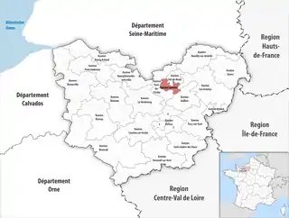 Lage des Kantons Louviers im Département Eure | |
Gemeinden
Der Kanton besteht aus sieben Gemeinden mit insgesamt 24.481 Einwohnern (Stand: 1. Januar 2019) auf einer Gesamtfläche von 58,70 km²:
| Gemeinde | Einwohner 1. Januar 2019 |
Fläche km² |
Dichte Einw./km² |
Code INSEE |
Postleitzahl |
|---|---|---|---|---|---|
| Andé | 1.303 | 5,16 | 253 | 27015 | 27430 |
| Heudebouville | 782 | 9,34 | 84 | 27332 | 27400, 27600 |
| Incarville | 1.423 | 7,03 | 202 | 27351 | 27400 |
| Louviers | 18.518 | 27,13 | 683 | 27375 | 27400 |
| Saint-Étienne-du-Vauvray | 876 | 1,69 | 518 | 27537 | 27430 |
| Saint-Pierre-du-Vauvray | 1.249 | 4,50 | 278 | 27598 | 27430 |
| Vironvay | 330 | 3,85 | 86 | 27697 | 27400 |
| Kanton Louviers | 24.481 | 58,70 | 417 | 2714 | – |
This article is issued from Wikipedia. The text is licensed under Creative Commons - Attribution - Sharealike. The authors of the article are listed here. Additional terms may apply for the media files, click on images to show image meta data.