Kanton Pont-de-l’Arche
Der Kanton Pont-de-l’Arche ist eine französische Verwaltungseinheit im Arrondissement Les Andelys im Département Eure in der Region Normandie; sein Hauptort ist Pont-de-l’Arche, Vertreter im Generalrat des Départements ist seit 2004 Gaëtan Levitre (PCF). Seit 2015 ist Maryannick Deshayes (EELV) hinzugekommen.
| Kanton Pont-de-l’Arche | |
|---|---|
| Region | Normandie |
| Département | Eure |
| Arrondissement | Les Andelys |
| Hauptort | Pont-de-l’Arche |
| Einwohner | 23.802 (1. Jan. 2019) |
| Bevölkerungsdichte | 143 Einw./km² |
| Fläche | 166,67 km² |
| Gemeinden | 20 |
| INSEE-Code | 2718 |
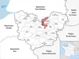 Lage des Kantons Pont-de-l’Arche im Département Eure | |
Geografie
Der Kanton Pont-de-l’Arche ist 166,45 km² groß und hat (2019) 23.802 Einwohner, was einer Bevölkerungsdichte von 143 Einwohnern pro km² entspricht. Er liegt im Mittel auf 56 Meter über dem Meeresspiegel, zwischen 2 m in Les Damps und 159 m in Montaure.
Gemeinden
Der Kanton besteht aus 20 Gemeinden mit insgesamt 23.802 Einwohnern (Stand: 1. Januar 2019) auf einer Gesamtfläche von 166,67 km²:
| Gemeinde | Einwohner 1. Januar 2019 |
Fläche km² |
Dichte Einw./km² |
Code INSEE |
Postleitzahl |
|---|---|---|---|---|---|
| Acquigny | 1.619 | 17,90 | 90 | 27003 | 27400 |
| Alizay | 1.592 | 8,71 | 183 | 27008 | 27460 |
| Amfreville-sur-Iton | 848 | 5,39 | 157 | 27014 | 27400 |
| Crasville | 124 | 2,47 | 50 | 27184 | 27400 |
| Criquebeuf-sur-Seine | 1.489 | 14,68 | 101 | 27188 | 27340 |
| Igoville | 1.756 | 5,69 | 309 | 27348 | 27460 |
| La Haye-le-Comte | 134 | 3,34 | 40 | 27321 | 27400 |
| La Haye-Malherbe | 1.392 | 9,99 | 139 | 27322 | 27400 |
| La Vacherie | 565 | 7,61 | 74 | 27666 | 27400 |
| Le Manoir | 1.329 | 2,41 | 551 | 27386 | 27460 |
| Le Mesnil-Jourdain | 236 | 10,46 | 23 | 27403 | 27400 |
| Les Damps | 1.371 | 4,77 | 287 | 27196 | 27340 |
| Martot | 492 | 8,39 | 59 | 27394 | 27340 |
| Pinterville | 760 | 5,99 | 127 | 27456 | 27400 |
| Pîtres | 2.648 | 10,98 | 241 | 27458 | 27590 |
| Pont-de-l’Arche | 4.146 | 9,44 | 439 | 27469 | 27340 |
| Quatremare | 435 | 5,95 | 73 | 27483 | 27400 |
| Surtauville | 492 | 4,42 | 111 | 27623 | 27400 |
| Surville | 883 | 5,75 | 154 | 27624 | 27400 |
| Terres de Bord | 1.491 | 22,33 | 67 | 27412 | 27340, 27400 |
| Kanton Pont-de-l’Arche | 23.802 | 166,67 | 143 | 2718 | – |
Bis zur landesweiten Neuordnung der Kantone 2015 bestand der Kanton Pont-de-l’Arche aus den 10 Gemeinden Alizay, Criquebeuf-sur-Seine, Les Damps, Igoville, Le Manoir, Martot, Montaure, Pîtres, Pont-de-l’Arche und Tostes. Sein Zuschnitt entsprach einer Fläche von 87,34 km2.
Veränderungen im Gemeindebestand seit der landesweiten Neuordnung der Kantone
2017: Fusion Montaure und Tostes → Terres de Bord
Bevölkerungsentwicklung
| 1962 | 1968 | 1975 | 1982 | 1990 | 1999 |
|---|---|---|---|---|---|
| 9.004 | 10.468 | 11.373 | 11.119 | 12.313 | 13.367 |
Weblinks
- Kanton Pont-de-l’Arche auf der Website des Insee
- Lokalisation des Kantons Pont-de-l’Arche auf einer Frankreichkarte