Fort-Moville
| Fort-Moville | ||
|---|---|---|

|
| |
| Staat | Frankreich | |
| Region | Normandie | |
| Département (Nr.) | Eure (27) | |
| Arrondissement | Bernay | |
| Kanton | Beuzeville | |
| Gemeindeverband | Lieuvin Pays d’Auge | |
| Koordinaten | 49° 20′ N, 0° 25′ O | |
| Höhe | 38–142 m | |
| Fläche | 9,35 km² | |
| Einwohner | 522 (1. Januar 2019) | |
| Bevölkerungsdichte | 56 Einw./km² | |
| Postleitzahl | 27210 | |
| INSEE-Code | 27258 | |

Fort-Moville ist eine französische Gemeinde mit 522 Einwohnern (Stand: 1. Januar 2019) im Département Eure in der Region Normandie. Sie gehört zum Arrondissement Bernay und ist Teil des Kantons Beuzeville. Die Einwohner werden Fort-Movillais genannt.
Geografie
Fort-Moville liegt etwa 28 Kilometer südöstlich von Le Havre. Umgeben wird Fort-Moville von den Nachbargemeinden Saint-Maclou im Norden und Nordosten, Triqueville im Osten, Martainville im Süden sowie Le Torpt im Westen.
Durch die Gemeinde führt die Autoroute A13.
Bevölkerungsentwicklung
| 1962 | 1968 | 1975 | 1982 | 1990 | 1999 | 2006 | 2013 |
|---|---|---|---|---|---|---|---|
| 330 | 266 | 241 | 244 | 261 | 312 | 367 | 449 |
| Quelle: Cassini und INSEE | |||||||
Sehenswürdigkeiten
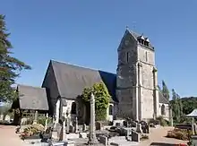
Kirche Saint-Jean-Baptiste
- Kirche Saint-Jean-Baptiste aus dem 14. Jahrhundert, Umbauten aus dem 16. Jahrhundert
- Pfarrhaus aus dem 17. Jahrhundert
- Schloss La Fosse
This article is issued from Wikipedia. The text is licensed under Creative Commons - Attribution - Sharealike. The authors of the article are listed here. Additional terms may apply for the media files, click on images to show image meta data.