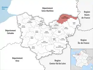
Kanton Romilly-sur-Andelle
Der Kanton Romilly-sur-Andelle ist ein französischer Wahlkreis im Arrondissement Les Andelys im Département Eure in der Region Normandie; sein Hauptort ist Romilly-sur-Andelle.
| Kanton Romilly-sur-Andelle | |
|---|---|
| Region | Normandie |
| Département | Eure |
| Arrondissement | Les Andelys |
| Hauptort | Romilly-sur-Andelle |
| Einwohner | 21.860 (1. Jan. 2019) |
| Bevölkerungsdichte | 71 Einw./km² |
| Fläche | 307,57 km² |
| Gemeinden | 35 |
| INSEE-Code | 2719 |
 Lage des Kantons Romilly-sur-Andelle im Département Eure | |
Gemeinden
Der Kanton besteht aus 35 Gemeinden mit insgesamt 21.860 Einwohnern (Stand: 1. Januar 2019) auf einer Gesamtfläche von 307,57 km²:
| Gemeinde | Einwohner 1. Januar 2019 |
Fläche km² |
Dichte Einw./km² |
Code INSEE |
Postleitzahl |
|---|---|---|---|---|---|
| Amfreville-les-Champs | 447 | 6,50 | 69 | 27012 | 27380 |
| Bacqueville | 632 | 11,04 | 57 | 27034 | 27440 |
| Beauficel-en-Lyons | 187 | 7,21 | 26 | 27048 | 27480 |
| Bézu-la-Forêt | 328 | 8,97 | 37 | 27066 | 27480 |
| Bosquentin | 126 | 6,92 | 18 | 27094 | 27480 |
| Bouchevilliers | 83 | 4,37 | 19 | 27098 | 27150 |
| Bourg-Beaudouin | 702 | 5,32 | 132 | 27104 | 27380 |
| Charleval | 1.734 | 14,08 | 123 | 27151 | 27300 |
| Douville-sur-Andelle | 452 | 4,52 | 100 | 27205 | 27380 |
| Fleury-la-Forêt | 259 | 7,83 | 33 | 27245 | 27480 |
| Fleury-sur-Andelle | 1.834 | 3,76 | 488 | 27246 | 27380 |
| Flipou | 324 | 6,98 | 46 | 27247 | 27380 |
| Houville-en-Vexin | 234 | 8,05 | 29 | 27346 | 27440 |
| Les Hogues | 674 | 11,68 | 58 | 27338 | 27910 |
| Le Tronquay | 513 | 19,07 | 27 | 27664 | 27480 |
| Letteguives | 207 | 4,13 | 50 | 27366 | 27910 |
| Lilly | 79 | 6,06 | 13 | 27369 | 27480 |
| Lisors | 329 | 10,81 | 30 | 27370 | 27440 |
| Lorleau | 118 | 12,35 | 10 | 27373 | 27480 |
| Lyons-la-Forêt | 712 | 27,16 | 26 | 27377 | 27480 |
| Mainneville | 444 | 8,14 | 55 | 27379 | 27150 |
| Martagny | 150 | 4,42 | 34 | 27392 | 27150 |
| Ménesqueville | 467 | 4,13 | 113 | 27396 | 27850 |
| Mesnil-sous-Vienne | 102 | 5,72 | 18 | 27405 | 27150 |
| Perriers-sur-Andelle | 1.802 | 11,30 | 159 | 27453 | 27910 |
| Perruel | 465 | 5,44 | 85 | 27454 | 27910 |
| Pont-Saint-Pierre | 1.134 | 6,97 | 163 | 27470 | 27360 |
| Radepont | 662 | 15,91 | 42 | 27487 | 27380 |
| Renneville | 194 | 6,28 | 31 | 27488 | 27910 |
| Romilly-sur-Andelle | 3.288 | 8,58 | 383 | 27493 | 27610 |
| Rosay-sur-Lieure | 516 | 8,12 | 64 | 27496 | 27790 |
| Touffreville | 353 | 10,75 | 33 | 27649 | 27440 |
| Val d’Orger | 991 | 11,02 | 90 | 27294 | 27380, 27440 |
| Vandrimare | 961 | 6,52 | 147 | 27670 | 27380 |
| Vascœuil | 357 | 7,46 | 48 | 27672 | 27910 |
| Kanton Romilly-sur-Andelle | 21.860 | 307,57 | 71 | 2719 | – |
Veränderungen im Gemeindebestand seit der landesweiten Neuordnung der Kantone
2017: Fusion Gaillardbois-Cressenville und Grainville → Val d’Orger
This article is issued from Wikipedia. The text is licensed under Creative Commons - Attribution - Sharealike. The authors of the article are listed here. Additional terms may apply for the media files, click on images to show image meta data.