Kanton Grand Bourgtheroulde
Der Kanton Grand Bourgtheroulde (früher Bourgtheroulde-Infreville) ist ein französischer Wahlkreis im Arrondissement Bernay, im Département Eure und in der Region Normandie; sein Hauptort ist Grand Bourgtheroulde, Vertreter im Generalrat des Départements ist seit 2001 Jean Guenier.
| Kanton Grand Bourgtheroulde | |
|---|---|
| Region | Normandie |
| Département | Eure |
| Arrondissement | Bernay |
| Hauptort | Grand Bourgtheroulde |
| Einwohner | 28.584 (1. Jan. 2019) |
| Bevölkerungsdichte | 149 Einw./km² |
| Fläche | 192,21 km² |
| Gemeinden | 25 |
| INSEE-Code | 2705 |
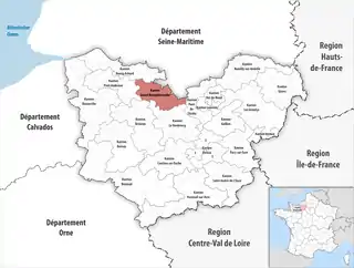 Lage des Kantons Grand Bourgtheroulde im Département Eure | |
Der Kanton Grand Bourgtheroulde liegt im Mittel auf 133 Meter über dem Meeresspiegel, zwischen 60 m in Saint-Ouen-du-Tilleul und 173 m in Bosguérard-de-Marcouville.
Gemeinden
Der Kanton besteht aus 25 Gemeinden mit insgesamt 28.584 Einwohnern (Stand: 1. Januar 2019) auf einer Gesamtfläche von 192,21 km²:
| Gemeinde | Einwohner 1. Januar 2019 |
Fläche km² |
Dichte Einw./km² |
Code INSEE |
Postleitzahl |
|---|---|---|---|---|---|
| Amfreville-Saint-Amand | 1.196 | 9,68 | 124 | 27011 | 27370 |
| Boissey-le-Châtel | 856 | 4,40 | 195 | 27077 | 27520 |
| Bosroumois | 3.649 | 13,36 | 273 | 27090 | 27670 |
| Flancourt-Crescy-en-Roumois | 1.517 | 19,14 | 79 | 27085 | 27310 |
| Fouqueville | 448 | 8,19 | 55 | 27261 | 27370 |
| Grand Bourgtheroulde | 3.957 | 19,64 | 201 | 27105 | 27520 |
| La Harengère | 609 | 3,65 | 167 | 27313 | 27370 |
| La Haye-du-Theil | 304 | 7,07 | 43 | 27320 | 27370 |
| La Saussaye | 1.890 | 3,52 | 537 | 27616 | 27370 |
| Le Bec-Thomas | 219 | 1,41 | 155 | 27053 | 27370 |
| Les Monts du Roumois | 1.567 | 23,97 | 65 | 27062 | 27370, 27520 |
| Le Thuit de l’Oison | 3.700 | 15,66 | 236 | 27638 | 27370 |
| Saint-Cyr-la-Campagne | 435 | 2,91 | 149 | 27529 | 27370 |
| Saint-Denis-des-Monts | 206 | 3,91 | 53 | 27531 | 27520 |
| Saint-Didier-des-Bois | 886 | 5,87 | 151 | 27534 | 27370 |
| Saint-Germain-de-Pasquier | 123 | 2,00 | 62 | 27545 | 27370 |
| Saint-Léger-du-Gennetey | 179 | 3,32 | 54 | 27558 | 27520 |
| Saint-Ouen-de-Pontcheuil | 99 | 1,13 | 88 | 27579 | 27370 |
| Saint-Ouen-du-Tilleul | 1.696 | 4,02 | 422 | 27582 | 27670 |
| Saint-Philbert-sur-Boissey | 173 | 3,07 | 56 | 27586 | 27520 |
| Saint-Pierre-des-Fleurs | 1.614 | 2,82 | 572 | 27593 | 27370 |
| Saint-Pierre-du-Bosguérard | 1.012 | 10,23 | 99 | 27595 | 27370 |
| Thénouville | 1.009 | 13,40 | 75 | 27089 | 27520 |
| Tourville-la-Campagne | 1.121 | 8,10 | 138 | 27654 | 27370 |
| Voiscreville | 119 | 1,74 | 68 | 27699 | 27520 |
| Kanton Grand Bourgtheroulde | 28.584 | 192,21 | 149 | 2705 | – |
Bis zur Neuordnung bestand der Kanton Bourgtheroulde-Infreville aus den 18 Gemeinden Berville-en-Roumois, Boissey-le-Châtel, Bosc-Bénard-Commin, Bosc-Bénard-Crescy, Bosc-Renoult-en-Roumois, Le Bosc-Roger-en-Roumois, Bosguérard-de-Marcouville, Bosnormand, Bourgtheroulde-Infreville, Épreville-en-Roumois, Flancourt-Catelon, Saint-Denis-des-Monts, Saint-Léger-du-Gennetey, Saint-Ouen-du-Tilleul, Saint-Philbert-sur-Boissey, Theillement, Thuit-Hébert und Voiscreville. Sein Zuschnitt entsprach einer Fläche von 102,95 km2.
Veränderungen im Gemeindebestand seit der landesweiten Neuordnung der Kantone
2018:
- Fusion Thénouville und Touville (Kanton Pont-Audemer) → Thénouville
2017:
- Fusion Bosnormand und Le Bosc-Roger-en-Roumois → Bosroumois
- Fusion Berville-en-Roumois, Bosguérard-de-Marcouville und Houlbec-près-le-Gros-Theil → Les Monts du Roumois
- Fusion Bosc-Renoult-en-Roumois und Theillement → Thénouville
2016:
- Fusion Amfreville-la-Campagne und Saint-Amand-des-Hautes-Terres → Amfreville-Saint-Amand
- Fusion Bosc-Bénard-Crescy, Épreville-en-Roumois und Flancourt-Catelon → Flancourt-Crescy-en-Roumois
- Fusion Bosc-Bénard-Commin, Bourgtheroulde-Infreville und Thuit-Hébert → Grand Bourgtheroulde
- Fusion Le Thuit-Anger, Le Thuit-Signol und Le Thuit-Simer → Le Thuit de l’Oison
Bevölkerungsentwicklung
| 1962 | 1968 | 1975 | 1982 | 1990 | 1999 |
|---|---|---|---|---|---|
| 5526 | 6338 | 7587 | 10.452 | 11.920 | 12.129 |