Willies
Willies ist eine Gemeinde im Norden Frankreichs. Sie gehört zur Region Hauts-de-France, zum Département Nord, zum Arrondissement Avesnes-sur-Helpe und zum Kanton Fourmies. Die Gemeinde liegt nahe der Grenze zu Belgien an der Helpe Majeure, die hier zum Stausee Lac du Val de Joly aufgestaut ist. Sie grenzt im Norden an Felleries, im Nordosten an Clairfayts (Berührungspunkt), im Osten an Eppe-Sauvage, im Süden an Trélon und im Westen an Liessies.
| Willies | ||
|---|---|---|
_Nord-France.svg.png.webp)
|
| |
| Staat | Frankreich | |
| Region | Hauts-de-France | |
| Département (Nr.) | Nord (59) | |
| Arrondissement | Avesnes-sur-Helpe | |
| Kanton | Fourmies | |
| Gemeindeverband | Sud Avesnois | |
| Koordinaten | 50° 7′ N, 4° 6′ O | |
| Höhe | 162–230 m | |
| Fläche | 4,13 km² | |
| Einwohner | 136 (1. Januar 2019) | |
| Bevölkerungsdichte | 33 Einw./km² | |
| Postleitzahl | 59740 | |
| INSEE-Code | 59661 | |
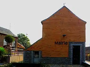
 Mairie Willies | ||
Bevölkerungsentwicklung
| Jahr | 1962 | 1968 | 1975 | 1982 | 1990 | 1999 | 2008 | 2013 |
|---|---|---|---|---|---|---|---|---|
| Einwohner | 134 | 137 | 107 | 105 | 128 | 139 | 158 | 159 |
_barrage_Lac_du_Val_Joly.jpg.webp) Stausee Lac du Val Joly
Stausee Lac du Val Joly Taubenschlag
Literatur
- Le Patrimoine des Communes du Nord. Flohic Editions, Band 2, Paris 2001, ISBN 2-84234-119-8, S. 1644–1645.
Weblinks
Commons: Willies – Sammlung von Bildern, Videos und Audiodateien
This article is issued from Wikipedia. The text is licensed under Creative Commons - Attribution - Sharealike. The authors of the article are listed here. Additional terms may apply for the media files, click on images to show image meta data.
