Saint-Hilaire-sur-Helpe
Saint-Hilaire-sur-Helpe ist eine Gemeinde im französischen Département Nord in der Region Hauts-de-France. Sie gehört zum Kanton Avesnes-sur-Helpe (bis 2015 Kanton Avesnes-sur-Helpe-Nord) im Arrondissement Avesnes-sur-Helpe. Die Bewohner nennen sich Saint-Hilairois.
| Saint-Hilaire-sur-Helpe | ||
|---|---|---|
.svg.png.webp)
|
| |
| Staat | Frankreich | |
| Region | Hauts-de-France | |
| Département (Nr.) | Nord (59) | |
| Arrondissement | Avesnes-sur-Helpe | |
| Kanton | Avesnes-sur-Helpe | |
| Gemeindeverband | Cœur de l’Avesnois | |
| Koordinaten | 50° 8′ N, 3° 54′ O | |
| Höhe | 140–206 m | |
| Fläche | 15,39 km² | |
| Einwohner | 827 (1. Januar 2019) | |
| Bevölkerungsdichte | 54 Einw./km² | |
| Postleitzahl | 59440 | |
| INSEE-Code | 59534 | |
_mairie.jpg.webp) Mairie (Rathaus) | ||

Geographie
Der Ort grenzt im Nordwesten an Monceau-Saint-Waast (Berührungspunkt) und Saint-Remy-Chaussée, im Norden an Saint-Aubin, im Nordosten an Dourlers (Berührungspunkt), im Osten an Bas-Lieu und Avesnes-sur-Helpe, im Südosten an Haut-Lieu, im Südwesten an Cartignies und Petit-Fayt und im Westen an Dompierre-sur-Helpe.
Die vormalige Route nationale 351 führt über Saint-Hilaire-sur-Helpe.
_moulin_%C3%A0_Fuchau.jpg.webp) Die Helpe Majeure bei Saint-Hilaire-sur-Helpe
Die Helpe Majeure bei Saint-Hilaire-sur-Helpe_chapelle_de_Marie_devant_l'%C3%A9glise.jpg.webp) Marienkapelle (Chapelle de Marie), Monument historique nahe der Dorfkirche
Marienkapelle (Chapelle de Marie), Monument historique nahe der Dorfkirche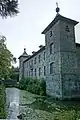 Château de Coutant, Monument historique
Bevölkerungsentwicklung
| Jahr | 1962 | 1968 | 1975 | 1982 | 1990 | 1999 | 2007 | 2013 |
|---|---|---|---|---|---|---|---|---|
| Einwohner | 927 | 915 | 842 | 833 | 846 | 779 | 773 | 781 |
Baudenkmäler
Siehe: Liste der Monuments historiques in Saint-Hilaire-sur-Helpe
Literatur
- Le Patrimoine des Communes du Nord. Flohic Editions, Band 1, Paris 2001, ISBN 2-84234-119-8, S. 160–162.
Weblinks
Commons: Saint-Hilaire-sur-Helpe – Sammlung von Bildern, Videos und Audiodateien
This article is issued from Wikipedia. The text is licensed under Creative Commons - Attribution - Sharealike. The authors of the article are listed here. Additional terms may apply for the media files, click on images to show image meta data.