Mecquignies
Mecquignies ist eine Gemeinde mit 720 Einwohnern (Stand 1. Januar 2019) im französischen Département Nord in der Region Hauts-de-France. Sie gehört zum Kanton Aulnoye-Aymeries (bis 2015 Kanton Bavay) im Arrondissement Avesnes-sur-Helpe. Sie grenzt im Norden an Bavay, im Osten an Audignies, im Süden an Locquignol und im Westen an Obies.
| Mecquignies | ||
|---|---|---|
.svg.png.webp)
|
| |
| Staat | Frankreich | |
| Region | Hauts-de-France | |
| Département (Nr.) | Nord (59) | |
| Arrondissement | Avesnes-sur-Helpe | |
| Kanton | Aulnoye-Aymeries | |
| Gemeindeverband | Pays de Mormal | |
| Koordinaten | 50° 17′ N, 3° 48′ O | |
| Höhe | 118–160 m | |
| Fläche | 4,72 km² | |
| Einwohner | 720 (1. Januar 2019) | |
| Bevölkerungsdichte | 153 Einw./km² | |
| Postleitzahl | 59570 | |
| INSEE-Code | 59396 | |
_mairie.JPG.webp) Mairie Mecquignies | ||

Die vormalige Route nationale 32 führt über Mecquignies.
Bevölkerungsentwicklung
| Jahr | 1962 | 1968 | 1975 | 1982 | 1990 | 1999 | 2008 | 2017 |
|---|---|---|---|---|---|---|---|---|
| Einwohner | 632 | 574 | 519 | 515 | 584 | 584 | 609 | 702 |
Sehenswürdigkeiten
- Kirche Saint-Achard, Monument historique (siehe auch: Liste der Monuments historiques in Mecquignies)
- Kriegerdenkmal
- Bildstöcke
- Modellwindmühlen in einem Garten
_%C3%A9glise%252C_vue_lat%C3%A9rale.JPG.webp) Kirche Saint-Achard
Kirche Saint-Achard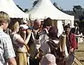 jährlich stattfindendes Mittelalter-Fest in Mecquignies
_model_windmills.JPG.webp) Modellwindmühlen
Modellwindmühlen
Literatur
- Le Patrimoine des Communes du Nord. Flohic Editions, Band 1, Paris 2001, ISBN 2-84234-119-8, S. 235–237.
Weblinks
Commons: Mecquignies – Sammlung von Bildern, Videos und Audiodateien
This article is issued from Wikipedia. The text is licensed under Creative Commons - Attribution - Sharealike. The authors of the article are listed here. Additional terms may apply for the media files, click on images to show image meta data.