Thoury-Férottes
Thoury-Férottes ist eine französische Gemeinde im Département Seine-et-Marne in der Region Île-de-France. Sie gehört zum Arrondissement Provins und zum Kanton Nemours (bis 2015 Kanton Lorrez-le-Bocage-Préaux). Die Bewohner nennen sich Ferottois. Thoury-Férottes grenzt im Nordwesten an Flagy, im Norden an Noisy-Rudignon, im Nordosten an Esmans und Montmachoux (Berührungspunkt), im Osten an Voulx, im Süden an Chevry-en-Sereine und im Südwesten an Lorrez-le-Bocage-Préaux und Saint-Ange-le-Viel.
| Thoury-Férottes | ||
|---|---|---|
| ||
| Staat | Frankreich | |
| Region | Île-de-France | |
| Département (Nr.) | Seine-et-Marne (77) | |
| Arrondissement | Provins | |
| Kanton | Nemours | |
| Gemeindeverband | Pays de Montereau | |
| Koordinaten | 48° 18′ N, 2° 57′ O | |
| Höhe | 72–152 m | |
| Fläche | 16,46 km² | |
| Einwohner | 655 (1. Januar 2019) | |
| Bevölkerungsdichte | 40 Einw./km² | |
| Postleitzahl | 77940 | |
| INSEE-Code | 77465 | |
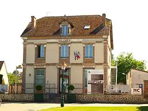 Mairie von Thoury-Férottes | ||

Bevölkerungsentwicklung
| Jahr | 1962 | 1968 | 1975 | 1982 | 1990 | 1999 | 2008 | 2013 |
|---|---|---|---|---|---|---|---|---|
| Einwohner | 474 | 418 | 404 | 407 | 480 | 609 | 620 | 693 |
Sehenswürdigkeiten
Siehe auch: Liste der Monuments historiques in Thoury-Férottes
- Soldatenfriedhof
- Kriegerdenkmal
- Kirche Saint-Pierre-Saint-Paul
- zwei Meter hoher Menhir „Pierre Cornoise“, Monument historique
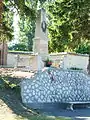 Kriegerdenkmal
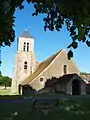 Kirche Saint-Pierre-Saint-Paul
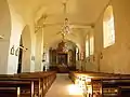 Kirchenschiff
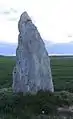 Menhir Pierre Cornoise
Literatur
- Le Patrimoine des Communes de la Seine-et-Marne. Flohic Editions, Band 1, Paris 2001, ISBN 2-84234-100-7, S. 688–689.
This article is issued from Wikipedia. The text is licensed under Creative Commons - Attribution - Sharealike. The authors of the article are listed here. Additional terms may apply for the media files, click on images to show image meta data.