Rampillon
Rampillon ist eine französische Gemeinde mit 826 Einwohnern (Stand: 1. Januar 2019) im Département Seine-et-Marne in der Region Île-de-France. Sie gehört zum Arrondissement Provins und zum Kanton Nangis. Die Einwohner heißen Rampillonais.
| Rampillon | ||
|---|---|---|
| ||
| Staat | Frankreich | |
| Region | Île-de-France | |
| Département (Nr.) | Seine-et-Marne (77) | |
| Arrondissement | Provins | |
| Kanton | Nangis | |
| Gemeindeverband | Brie Nangissienne | |
| Koordinaten | 48° 33′ N, 3° 4′ O | |
| Höhe | 120–144 m | |
| Fläche | 23,08 km² | |
| Einwohner | 826 (1. Januar 2019) | |
| Bevölkerungsdichte | 36 Einw./km² | |
| Postleitzahl | 77370 | |
| INSEE-Code | 77383 | |
_Mairie.jpg.webp) Rathaus (Mairie) von Rampillon | ||
Geographie
Rampillon liegt etwa 63 Kilometer südöstlich von Paris. Umgeben wird Rampillon von den Nachbargemeinden La Croix-en-Brie im Norden, Vanvillé im Osten und Nordosten, Sognolles-en-Montois im Osten und Südosten, Meigneux im Süden und Südosten, Villeneuve-les-Bordes im Süden und Südwesten, Fontains im Südwesten sowie Nangis im Westen. Am Nordrand der Gemeinde führt die frühere Route nationale 19 (heutige D619) entlang.
Bevölkerungsentwicklung
| Jahr | 1962 | 1968 | 1975 | 1982 | 1990 | 1999 | 2006 | 2013 |
| Einwohner | 422 | 348 | 407 | 561 | 651 | 607 | 762 | 806 |
| Quelle: Cassini und INSEE | ||||||||
Sehenswürdigkeiten
Siehe auch: Liste der Monuments historiques in Rampillon
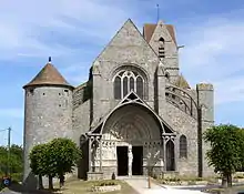
- Kirche Saint-Éliphe aus dem 13. Jahrhundert, Monument historique

Kirche Saint-Éliphe
Persönlichkeiten
- Eliphius von Rampillon (vermutlich 362 verstorben), Diakon und Märtyrer der christlichen Kirche
Literatur
- Le Patrimoine des Communes de la Seine-et-Marne. Flohic Editions, Band 2, Paris 2001, ISBN 2-84234-100-7, S. 1115–1118.
This article is issued from Wikipedia. The text is licensed under Creative Commons - Attribution - Sharealike. The authors of the article are listed here. Additional terms may apply for the media files, click on images to show image meta data.
