Montolivet
Montolivet ist eine französische Gemeinde im Département Seine-et-Marne in der Île-de-France. Die Bewohner nennen sich Montolivetains. Nachbargemeinden sind Verdelot im Nordwesten, Montdauphin im Norden, Dhuys et Morin-en-Brie mit La Celle-sous-Montmirail im Nordosten, Montenils im Osten, Le Vézier im Süden, Meilleray im Südwesten und Saint-Barthélemy im Westen.
| Montolivet | ||
|---|---|---|
| ||
| Staat | Frankreich | |
| Region | Île-de-France | |
| Département (Nr.) | Seine-et-Marne (77) | |
| Arrondissement | Provins | |
| Kanton | Coulommiers | |
| Gemeindeverband | Deux Morin | |
| Koordinaten | 48° 50′ N, 3° 26′ O | |
| Höhe | 153–203 m | |
| Fläche | 16,41 km² | |
| Einwohner | 236 (1. Januar 2019) | |
| Bevölkerungsdichte | 14 Einw./km² | |
| Postleitzahl | 77320 | |
| INSEE-Code | 77314 | |
 Montolivet | ||

Bevölkerungsentwicklung
| Jahr | 1962 | 1968 | 1975 | 1982 | 1990 | 1999 | 2008 | 2014 |
|---|---|---|---|---|---|---|---|---|
| Einwohner | 270 | 263 | 249 | 229 | 168 | 203 | 248 | 247 |
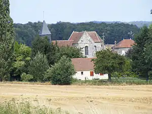
Sehenswürdigkeiten
- Kirche Saint-Ferréol (siehe auch: Liste der Monuments historiques in Montolivet)
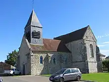
Kirche Saint-Ferréol
Literatur
- Le Patrimoine des Communes de la Seine-et-Marne. Flohic Editions, Band 1, Paris 2001, ISBN 2-84234-100-7, S. 523–524.
This article is issued from Wikipedia. The text is licensed under Creative Commons - Attribution - Sharealike. The authors of the article are listed here. Additional terms may apply for the media files, click on images to show image meta data.