Mortcerf
Mortcerf ist eine französische Gemeinde mit 1.431 Einwohnern (Stand: 1. Januar 2019) im Département Seine-et-Marne in der Region Île-de-France. Sie gehört zum Arrondissement Provins und zum Kanton Fontenay-Trésigny (bis 2015: Kanton Rozay-en-Brie). Die Einwohner werden Moressartois genannt.
| Mortcerf | ||
|---|---|---|
.svg.png.webp)
|
| |
| Staat | Frankreich | |
| Region | Île-de-France | |
| Département (Nr.) | Seine-et-Marne (77) | |
| Arrondissement | Provins | |
| Kanton | Fontenay-Trésigny | |
| Gemeindeverband | Val Briard | |
| Koordinaten | 48° 44′ N, 2° 57′ O | |
| Höhe | 74–140 m | |
| Fläche | 17,70 km² | |
| Einwohner | 1.431 (1. Januar 2019) | |
| Bevölkerungsdichte | 81 Einw./km² | |
| Postleitzahl | 77163 | |
| INSEE-Code | 77318 | |
| Website | http://www.mortcerf.fr/ | |
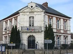 Rathaus (Mairie) | ||

Geographie
Mortcerf liegt etwa 42 Kilometer ostsüdöstlich von Paris. Umgeben wird Mortcerf von den Nachbargemeinden Dammartin-sur-Tigeaux im Norden, Guérard im Osten und Nordosten, Hautefeuille im Osten und Südosten, Lumigny-Nesles-Ormeaux im Süden und Südosten, Crèvecœur-en-Brie im Süden, La Houssaye-en-Brie im Süden und Südwesten, Neufmoutiers-en-Brie im Westen sowie Villeneuve-le-Comte im Nordwesten.
Bevölkerungsentwicklung
| Jahr | 1962 | 1968 | 1975 | 1982 | 1990 | 1999 | 2006 | 2013 |
| Einwohner | 738 | 793 | 758 | 822 | 1.072 | 1.307 | 1.416 | 1.454 |
| Quelle: Cassini und INSEE | ||||||||
Sehenswürdigkeiten
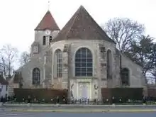
Kirche St-Pierre-St-Nicolas
Siehe auch: Liste der Monuments historiques in Mortcerf
- Kirche Saint-Pierre-Saint-Nicolas
- Burg Becoiseau
- Gutshof La Malmaison
Literatur
- Le Patrimoine des Communes de la Seine-et-Marne. Flohic Editions, Band 2, Paris 2001, ISBN 2-84234-100-7, S. 1340–1341.
This article is issued from Wikipedia. The text is licensed under Creative Commons - Attribution - Sharealike. The authors of the article are listed here. Additional terms may apply for the media files, click on images to show image meta data.