Thoisy-la-Berchère
Thoisy-la-Berchère ist eine französische Gemeinde mit 305 Einwohnern (Stand 1. Januar 2019) im Département Côte-d’Or in der Region Bourgogne-Franche-Comté. Sie gehört zum Kanton Semur-en-Auxois und zum Arrondissement Montbard.
| Thoisy-la-Berchère | ||
|---|---|---|
.svg.png.webp)
|
| |
| Staat | Frankreich | |
| Region | Bourgogne-Franche-Comté | |
| Département (Nr.) | Côte-d’Or (21) | |
| Arrondissement | Montbard | |
| Kanton | Semur-en-Auxois | |
| Gemeindeverband | Communauté de communes de Saulieu | |
| Koordinaten | 47° 16′ N, 4° 21′ O | |
| Höhe | 355–512 m | |
| Fläche | 34,95 km² | |
| Einwohner | 305 (1. Januar 2019) | |
| Bevölkerungsdichte | 9 Einw./km² | |
| Postleitzahl | 21210 | |
| INSEE-Code | 21629 | |

Sie grenzt im Nordwesten an Villargoix, im Norden an La Motte-Ternant, im Nordosten an Missery (Berührungspunkt) und Mont-Saint-Jean, im Osten an Marcilly-Ogny, im Südosten an Sussey, im Südwesten an Liernais und im Westen an Saulieu.
Bevölkerungsentwicklung
| Jahr | 1962 | 1968 | 1975 | 1982 | 1990 | 1999 | 2008 | 2015 | |
|---|---|---|---|---|---|---|---|---|---|
| Einwohner | 450 | 434 | 365 | 283 | 253 | 261 | 300 | 324 | |
| Quellen: Cassini und INSEE | |||||||||
Sehenswürdigkeiten
- Kirche Saint-Pierre, Monument historique seit 1971
Weblinks
Commons: Thoisy-la-Berchère – Sammlung von Bildern, Videos und Audiodateien
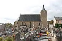
Kirche Saint-Pierre
This article is issued from Wikipedia. The text is licensed under Creative Commons - Attribution - Sharealike. The authors of the article are listed here. Additional terms may apply for the media files, click on images to show image meta data.