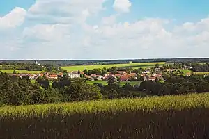
Buncey
Buncey ist eine französische Gemeinde mit 369 Einwohnern (Stand 1. Januar 2019) im Département Côte-d’Or in der Region Bourgogne-Franche-Comté. Sie gehört zum Kanton Châtillon-sur-Seine und zum Arrondissement Montbard.
| Buncey | ||
|---|---|---|
.svg.png.webp)
|
| |
| Staat | Frankreich | |
| Region | Bourgogne-Franche-Comté | |
| Département (Nr.) | Côte-d’Or (21) | |
| Arrondissement | Montbard | |
| Kanton | Châtillon-sur-Seine | |
| Gemeindeverband | Communauté de communes du Pays Châtillonnais | |
| Koordinaten | 47° 49′ N, 4° 34′ O | |
| Höhe | 222–334 m | |
| Fläche | 27,46 km² | |
| Einwohner | 369 (1. Januar 2019) | |
| Bevölkerungsdichte | 13 Einw./km² | |
| Postleitzahl | 21400 | |
| INSEE-Code | 21115 | |
 Buncey | ||

Geografie
Buncey wird von der ehemaligen Route nationale 71 tangiert. Diese wurde zu einer Départementsstraße abgestuft.
Nachbargemeinden sind Sainte-Colombe-sur-Seine im Nordwesten, Châtillon-sur-Seine im Norden, Villiers-le-Duc im Osten, Nod-sur-Seine im Süden, Chamesson im Südwesten und Ampilly-le-Sec im Westen.
Bevölkerungsentwicklung
| Jahr | 1962 | 1968 | 1975 | 1982 | 1990 | 1999 | 2008 | 2015 | |
|---|---|---|---|---|---|---|---|---|---|
| Einwohner | 353 | 352 | 286 | 364 | 395 | 386 | 379 | 382 | |
| Quellen: Cassini und INSEE | |||||||||
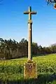 Eines der Flurkreuze im Gemeindegebiet
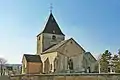 Kirche
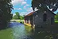
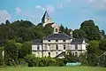 Mairie von Buncey
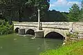 Flurkreuz und Brücke über die Seine
This article is issued from Wikipedia. The text is licensed under Creative Commons - Attribution - Sharealike. The authors of the article are listed here. Additional terms may apply for the media files, click on images to show image meta data.