Fontangy
Fontangy ist eine französische Gemeinde mit 133 Einwohnern (Stand 1. Januar 2019) im Département Côte-d’Or in der Region Bourgogne-Franche-Comté. Sie gehört zum Kanton Semur-en-Auxois und zum Arrondissement Montbard.
| Fontangy | ||
|---|---|---|
| ||
| Staat | Frankreich | |
| Region | Bourgogne-Franche-Comté | |
| Département (Nr.) | Côte-d’Or (21) | |
| Arrondissement | Montbard | |
| Kanton | Semur-en-Auxois | |
| Gemeindeverband | Communauté de communes des Terres d’Auxois | |
| Koordinaten | 47° 21′ N, 4° 21′ O | |
| Höhe | 345–561 m | |
| Fläche | 17,76 km² | |
| Einwohner | 133 (1. Januar 2019) | |
| Bevölkerungsdichte | 7 Einw./km² | |
| Postleitzahl | 21390 | |
| INSEE-Code | 21280 | |
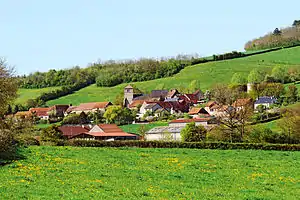 Fontangy beim Mont Ligot | ||

Nachbargemeinden sind Nan-sous-Thil im Nordwesten, Clamerey im Norden, Noidan im Osten, Charny im Südosten, Missery im Süden, La Motte-Ternant im Südwesten und Vic-sous-Thil im Westen.
Bevölkerungsentwicklung
| Jahr | 1962 | 1968 | 1975 | 1982 | 1990 | 1999 | 2008 | 2015 | |
|---|---|---|---|---|---|---|---|---|---|
| Einwohner | 208 | 204 | 181 | 166 | 153 | 147 | 152 | 148 | |
| Quellen: Cassini und INSEE | |||||||||
Weblinks
Commons: Fontangy – Sammlung von Bildern, Videos und Audiodateien
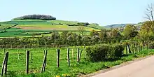
Der Mont Rond, eine Erhebung bei Fontangy
This article is issued from Wikipedia. The text is licensed under Creative Commons - Attribution - Sharealike. The authors of the article are listed here. Additional terms may apply for the media files, click on images to show image meta data.