Bure-les-Templiers
Bure-les-Templiers ist eine französische Gemeinde mit 134 Einwohnern (Stand 1. Januar 2019) im Département Côte-d’Or in der Region Bourgogne-Franche-Comté. Sie gehört zum Kanton Châtillon-sur-Seine und zum Arrondissement Montbard.
| Bure-les-Templiers | ||
|---|---|---|
.svg.png.webp)
|
| |
| Staat | Frankreich | |
| Region | Bourgogne-Franche-Comté | |
| Département (Nr.) | Côte-d’Or (21) | |
| Arrondissement | Montbard | |
| Kanton | Châtillon-sur-Seine | |
| Gemeindeverband | Communauté de communes du Pays Châtillonnais | |
| Koordinaten | 47° 44′ N, 4° 54′ O | |
| Höhe | 302–483 m | |
| Fläche | 35,26 km² | |
| Einwohner | 134 (1. Januar 2019) | |
| Bevölkerungsdichte | 4 Einw./km² | |
| Postleitzahl | 21290 | |
| INSEE-Code | 21116 | |
.jpg.webp) Bure-les-Templiers | ||

Nachbargemeinden sind Recey-sur-Ource im Nordwesten, Menesble im Norden, Colmier-le-Bas und Chaugey im Nordosten, Villars-Santenoge im Osten, Poinson-lès-Grancey im Südosten, Beneuvre im Süden, Minot im Südwesten und Saint-Broing-les-Moines und Terrefondrée im Westen.
Bevölkerungsentwicklung
| Jahr | 1962 | 1968 | 1975 | 1982 | 1990 | 1999 | 2008 | 2015 | |
|---|---|---|---|---|---|---|---|---|---|
| Einwohner | 235 | 211 | 172 | 154 | 130 | 150 | 130 | 138 | |
| Quellen: Cassini und INSEE | |||||||||
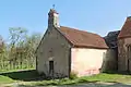
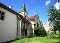
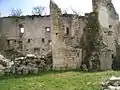
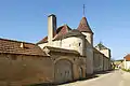
Sehenswürdigkeiten
This article is issued from Wikipedia. The text is licensed under Creative Commons - Attribution - Sharealike. The authors of the article are listed here. Additional terms may apply for the media files, click on images to show image meta data.