Les Goulles
Les Goulles ist eine französische Gemeinde mit 9 Einwohnern (Stand 1. Januar 2019) im Département Côte-d’Or in der Region Bourgogne-Franche-Comté. Sie gehört zum Kanton Châtillon-sur-Seine und zum Arrondissement Montbard.
| Les Goulles | ||
|---|---|---|
.svg.png.webp)
|
| |
| Staat | Frankreich | |
| Region | Bourgogne-Franche-Comté | |
| Département (Nr.) | Côte-d’Or (21) | |
| Arrondissement | Montbard | |
| Kanton | Châtillon-sur-Seine | |
| Gemeindeverband | Communauté de communes du Pays Châtillonnais | |
| Koordinaten | 47° 53′ N, 4° 54′ O | |
| Höhe | 270–372 m | |
| Fläche | 8,83 km² | |
| Einwohner | 9 (1. Januar 2019) | |
| Bevölkerungsdichte | 1 Einw./km² | |
| Postleitzahl | 21520 | |
| INSEE-Code | 21303 | |

Nachbargemeinden sind La Chaume im Nordwesten, Lignerolles im Norden, Aubepierre-sur-Aube im Osten, Gurgy-la-Ville im Südosten und Lucey im Südwesten.
Bevölkerungsentwicklung
| Jahr | 1962 | 1968 | 1975 | 1982 | 1990 | 1999 | 2008 | 2015 | |
|---|---|---|---|---|---|---|---|---|---|
| Einwohner | 36 | 26 | 22 | 21 | 19 | 12 | 15 | 15 | |
| Quellen: Cassini und INSEE | |||||||||
Weblinks
Commons: Les Goulles – Sammlung von Bildern, Videos und Audiodateien
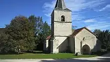
Kirche Sainte-Marie-Madeleine
This article is issued from Wikipedia. The text is licensed under Creative Commons - Attribution - Sharealike. The authors of the article are listed here. Additional terms may apply for the media files, click on images to show image meta data.