Thiouville
| Thiouville | ||
|---|---|---|
.svg.png.webp)
|
| |
| Staat | Frankreich | |
| Region | Normandie | |
| Département (Nr.) | Seine-Maritime (76) | |
| Arrondissement | Dieppe | |
| Kanton | Saint-Valery-en-Caux | |
| Gemeindeverband | Côte d’Albâtre | |
| Koordinaten | 49° 42′ N, 0° 37′ O | |
| Höhe | 114–140 m | |
| Fläche | 5,94 km² | |
| Einwohner | 293 (1. Januar 2019) | |
| Bevölkerungsdichte | 49 Einw./km² | |
| Postleitzahl | 76450 | |
| INSEE-Code | 76692 | |
| Website | https://www.thiouville.fr/ | |

Thiouville ist eine französische Gemeinde mit 293 Einwohnern (Stand: 1. Januar 2019) im Département Seine-Maritime in der Region Normandie (vor 2016 Haute-Normandie). Sie gehört zum Arrondissement Dieppe (bis 2017 Le Havre) und zum Kanton Saint-Valery-en-Caux (bis 2015 Ourville-en-Caux).
Geographie
Thiouville liegt etwa 50 Kilometer nordwestlich von Rouen. Umgeben wird Thiouville von den Nachbargemeinden Beuzeville-la-Guérard im Norden und Nordwesten, Cleuville im Norden und Nordosten, Ancourteville-sur-Héricourt im Osten, Cliponville im Südosten, Terres-de-Caux im Süden sowie Normanville im Westen.
Bevölkerungsentwicklung
| Jahr | 1962 | 1968 | 1975 | 1982 | 1990 | 1999 | 2006 | 2013 |
| Einwohner | 284 | 271 | 257 | 242 | 235 | 240 | 283 | 286 |
| Quelle: Cassini und INSEE | ||||||||
Sehenswürdigkeiten
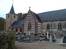
Kirche Saint-Vaast
- Kirche Saint-Vaast aus dem 16. Jahrhundert
- Schloss Thiouville aus dem 17. Jahrhundert
This article is issued from Wikipedia. The text is licensed under Creative Commons - Attribution - Sharealike. The authors of the article are listed here. Additional terms may apply for the media files, click on images to show image meta data.