Tendu
Tendu ist eine französische Gemeinde mit 648 Einwohnern (Stand 1. Januar 2019) im Département Indre in der Region Centre-Val de Loire; sie gehört zum Arrondissement Châteauroux und zum Kanton Argenton-sur-Creuse.
| Tendu | ||
|---|---|---|
| ||
| Staat | Frankreich | |
| Region | Centre-Val de Loire | |
| Département (Nr.) | Indre (36) | |
| Arrondissement | Châteauroux | |
| Kanton | Argenton-sur-Creuse | |
| Gemeindeverband | Éguzon-Argenton-Vallée de la Creuse | |
| Koordinaten | 46° 39′ N, 1° 34′ O | |
| Höhe | 107–174 m | |
| Fläche | 42,05 km² | |
| Einwohner | 648 (1. Januar 2019) | |
| Bevölkerungsdichte | 15 Einw./km² | |
| Postleitzahl | 36200 | |
| INSEE-Code | 36219 | |

Nachbargemeinden von Tendu sind Luant im Norden, Velles im Nordosten, Mosnay im Südosten, Le Pêchereau im Süden, Saint-Marcel im Südwesten, Chasseneuil und Le Pont-Chrétien-Chabenet im Westen und La Pérouille im Nordwesten.
Bevölkerungsentwicklung
| Jahr | 1962 | 1968 | 1975 | 1982 | 1990 | 1999 | 2007 | 2017 |
| Einwohner | 504 | 483 | 417 | 465 | 446 | 451 | 550 | 648 |
Sehenswürdigkeiten
- Schloss Prunget (12./14. Jahrhundert)
- Schloss Les Sallerons (19. Jahrhundert)
- Schloss Mazières
- Schloss La Rocherolle
- Schloss Le Broutay (15./16. Jahrhundert)
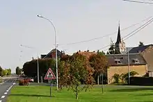
Blick auf Tendu
Weblinks
Commons: Tendu – Sammlung von Bildern, Videos und Audiodateien
This article is issued from Wikipedia. The text is licensed under Creative Commons - Attribution - Sharealike. The authors of the article are listed here. Additional terms may apply for the media files, click on images to show image meta data.