Pommiers (Indre)
Pommiers ist eine französische Gemeinde mit 214 Einwohnern (Stand: 1. Januar 2019) im Département Indre in der Region Centre-Val de Loire; sie gehört zum Arrondissement Châteauroux (bis 2017: Arrondissement La Châtre) und zum Kanton Argenton-sur-Creuse (bis 2015: Kanton Éguzon-Chantôme). Die Einwohner werden Bazaigeois genannt.
| Pommiers | ||
|---|---|---|
| ||
| Staat | Frankreich | |
| Region | Centre-Val de Loire | |
| Département (Nr.) | Indre (36) | |
| Arrondissement | Châteauroux | |
| Kanton | Argenton-sur-Creuse | |
| Gemeindeverband | Éguzon-Argenton-Vallée de la Creuse | |
| Koordinaten | 46° 31′ N, 1° 39′ O | |
| Höhe | 196–280 m | |
| Fläche | 12,31 km² | |
| Einwohner | 214 (1. Januar 2019) | |
| Bevölkerungsdichte | 17 Einw./km² | |
| Postleitzahl | 36190 | |
| INSEE-Code | 36160 | |
.JPG.webp) Rathaus (Mairie) von Pommiers | ||

Geographie
Pommiers liegt etwa 38 Kilometer südsüdwestlich von Châteauroux. Nachbargemeinden von Pommiers sind Malicornay im Norden, Orsennes im Osten und Südosten, Gargilesse-Dampierre im Süden und Westen, Badecon-le-Pin im Westen und Nordwesten sowie Chavin im Nordwesten.
Bevölkerungsentwicklung
| Jahr | 1962 | 1968 | 1975 | 1982 | 1990 | 1999 | 2006 | 2013 |
| Einwohner | 418 | 405 | 367 | 322 | 279 | 268 | 270 | 277 |
| Quelle: Cassini und INSEE | ||||||||
Sehenswürdigkeiten
- Kirche Sainte-Radegonde
- Schloss Le Châtelier, Monument historique seit 1965/2016
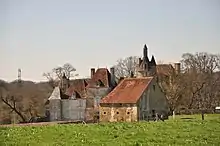
Schloss Le Châtelier
Weblinks
Commons: Pommiers – Sammlung von Bildern, Videos und Audiodateien
This article is issued from Wikipedia. The text is licensed under Creative Commons - Attribution - Sharealike. The authors of the article are listed here. Additional terms may apply for the media files, click on images to show image meta data.