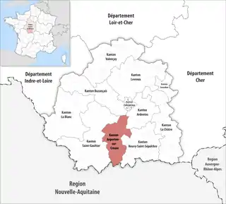
Kanton Argenton-sur-Creuse
Der Kanton Argenton-sur-Creuse ist ein französischer Wahlkreis im Arrondissement Châteauroux im Département Indre in der Region Centre-Val de Loire; sein Hauptort ist Argenton-sur-Creuse.
| Kanton Argenton-sur-Creuse | |
|---|---|
| Region | Centre-Val de Loire |
| Département | Indre |
| Arrondissement | Châteauroux |
| Hauptort | Argenton-sur-Creuse |
| Einwohner | 17.808 (1. Jan. 2019) |
| Bevölkerungsdichte | 40 Einw./km² |
| Fläche | 445,66 km² |
| Gemeinden | 20 |
| INSEE-Code | 3602 |
 Lage des Kantons Argenton-sur-Creuse im Département Indre | |
Gemeinden
Der Kanton besteht aus 20 Gemeinden mit insgesamt 17.808 Einwohnern (Stand: 1. Januar 2019) auf einer Gesamtfläche von 445,66 km²:
| Gemeinde | Einwohner 1. Januar 2019 |
Fläche km² |
Dichte Einw./km² |
Code INSEE |
Postleitzahl |
|---|---|---|---|---|---|
| Argenton-sur-Creuse | 4.880 | 29,28 | 167 | 36006 | 36200 |
| Badecon-le-Pin | 765 | 10,10 | 76 | 36158 | 36200 |
| Baraize | 363 | 16,48 | 22 | 36012 | 36270 |
| Bazaiges | 199 | 18,73 | 11 | 36014 | 36270 |
| Bouesse | 410 | 24,29 | 17 | 36022 | 36200 |
| Ceaulmont | 724 | 17,53 | 41 | 36032 | 36200 |
| Celon | 398 | 17,21 | 23 | 36033 | 36200 |
| Chasseneuil | 703 | 29,94 | 23 | 36042 | 36800 |
| Chavin | 271 | 14,04 | 19 | 36048 | 36200 |
| Cuzion | 441 | 18,86 | 23 | 36062 | 36190 |
| Éguzon-Chantôme | 1.345 | 36,27 | 37 | 36070 | 36270 |
| Gargilesse-Dampierre | 280 | 15,49 | 18 | 36081 | 36190 |
| Le Menoux | 429 | 5,49 | 78 | 36117 | 36200 |
| Le Pêchereau | 1.859 | 21,14 | 88 | 36154 | 36200 |
| Le Pont-Chrétien-Chabenet | 937 | 8,98 | 104 | 36161 | 36800 |
| Mosnay | 472 | 25,31 | 19 | 36131 | 36200 |
| Pommiers | 214 | 12,31 | 17 | 36160 | 36190 |
| Saint-Marcel | 1.506 | 17,83 | 84 | 36200 | 36200 |
| Tendu | 648 | 42,05 | 15 | 36219 | 36200 |
| Velles | 964 | 64,33 | 15 | 36231 | 36330 |
| Kanton Argenton-sur-Creuse | 17.808 | 445,66 | 40 | 3602 | – |
Bis zur landesweiten Neuordnung der französischen Kantone im März 2015 gehörten zum Kanton Argenton-sur-Creuse die elf Gemeinden Argenton-sur-Creuse, Bouesse, Celon, Chasseneuil, Chavin, Le Menoux, Le Pêchereau, Le Pont-Chrétien-Chabenet, Mosnay, Saint-Marcel und Tendu. Sein Zuschnitt entsprach einer Fläche von 235,27 km2. Er besaß vor 2015 den INSEE-Code 3603.
This article is issued from Wikipedia. The text is licensed under Creative Commons - Attribution - Sharealike. The authors of the article are listed here. Additional terms may apply for the media files, click on images to show image meta data.