Saint-Rémy-Blanzy
Saint-Rémy-Blanzy ist eine französische Gemeinde mit 221 Einwohnern (Stand: 1. Januar 2019) im Département Aisne in der Region Hauts-de-France (frühere Region: Picardie). Die Gemeinde gehört zum Arrondissement Soissons und ist Teil des Kantons Villers-Cotterêts.
| Saint-Rémy-Blanzy | ||
|---|---|---|
| ||
| Staat | Frankreich | |
| Region | Hauts-de-France | |
| Département (Nr.) | Aisne (02) | |
| Arrondissement | Soissons | |
| Kanton | Villers-Cotterêts | |
| Gemeindeverband | Communauté de communes du Canton d’Oulchy-le-Château | |
| Koordinaten | 49° 15′ N, 3° 19′ O | |
| Höhe | 96–208 m | |
| Fläche | 14,07 km² | |
| Einwohner | 221 (1. Januar 2019) | |
| Bevölkerungsdichte | 16 Einw./km² | |
| Postleitzahl | 02210 | |
| INSEE-Code | 02693 | |
_5260a.jpg.webp) Der Ort mit seinem markanten Kirchturm | ||
Geographie
Die rund 17,5 km südlich von Soissons an den Départementsstraßen D2 und D80 gelegene Gemeinde umfasst die Ortsteile Blanzy, La Fontaine aux Chènes (in der Nähe ein großer Steinbruch) und Fronteny. Nachbargemeinden sind Vierzy und Parcy-et-Tigny im Norden, Le Plessier-Huleu im Osten, Oulchy-la-Ville und Billy-sur-Ourcq im Süden und Louâtre und Villers-Hélon im Westen.
Bevölkerungsentwicklung
| Jahr | 1962 | 1968 | 1975 | 1982 | 1990 | 1999 | 2007 | 2015 |
| Einwohner | 239 | 234 | 149 | 125 | 212 | 203 | 230 | 211 |
| Quelle: Cassini und INSEE | ||||||||
Sehenswürdigkeiten
.JPG.webp)
Fensterrose der Kirche
.JPG.webp)
Gesamtansicht der Kirche

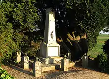
Kriegerdenkmal
- Die um 1460 errichtete Kirche Saint-Rémi, 1922 als Monument historique klassifiziert (Base Mérimée PA00115916).
- Die alte Vogtei (prévoté), 1928 als Monument historique eingetragen (Base Mérimée PA00115917).
- Das Kriegerdenkmal (Monument aux morts).
This article is issued from Wikipedia. The text is licensed under Creative Commons - Attribution - Sharealike. The authors of the article are listed here. Additional terms may apply for the media files, click on images to show image meta data.
