Le Plessier-Huleu
Le Plessier-Huleu ist eine Gemeinde mit 70 Einwohnern (Stand: 1. Januar 2019) im Département Aisne in der Region Hauts-de-France (frühere Region: Picardie). Die Gemeinde gehört zum Arrondissement Soissons und ist Teil des Kantons Villers-Cotterêts.
| Le Plessier-Huleu | ||
|---|---|---|
| ||
| Staat | Frankreich | |
| Region | Hauts-de-France | |
| Département (Nr.) | Aisne (02) | |
| Arrondissement | Soissons | |
| Kanton | Villers-Cotterêts | |
| Gemeindeverband | Communauté de communes du Canton d’Oulchy-le-Château | |
| Koordinaten | 49° 14′ N, 3° 21′ O | |
| Höhe | 132–203 m | |
| Fläche | 5,20 km² | |
| Einwohner | 70 (1. Januar 2019) | |
| Bevölkerungsdichte | 13 Einw./km² | |
| Postleitzahl | 02210 | |
| INSEE-Code | 02606 | |
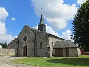
 Kirche Saint-Leu | ||
Geographie
Die Gemeinde, zu der die im Süden gelegene Häusergruppe von Martimpré gehört, liegt rund 17 Kilometer südlich von Soissons. Die östliche Begrenzung bildet teilweise eine Trasse der Chaussée Brunehaut. Nachbargemeinden sind Parcy-et-Tigny und Hartennes-et-Taux im Norden, Grand-Rozoy im Osten, Oulchy-le-Château und Oulchy-la-Ville im Süden und Saint-Rémy-Blanzy im Westen.
Bevölkerungsentwicklung
| Jahr | 1962 | 1968 | 1975 | 1982 | 1990 | 1999 | 2007 | 2015 |
| Einwohner | 101 | 88 | 71 | 47 | 44 | 77 | 79 | 73 |
| Quelle: Cassini und INSEE | ||||||||
Sehenswürdigkeiten
- Kirche Saint-Leu
This article is issued from Wikipedia. The text is licensed under Creative Commons - Attribution - Sharealike. The authors of the article are listed here. Additional terms may apply for the media files, click on images to show image meta data.
