Naillat
Naillat ist eine Gemeinde im Zentralmassiv in Frankreich. Sie gehört zur Region Nouvelle-Aquitaine, zum Département Creuse, zum Arrondissement Guéret und zum Kanton Dun-le-Palestel.
| Naillat | ||
|---|---|---|
| ||
| Staat | Frankreich | |
| Region | Nouvelle-Aquitaine | |
| Département (Nr.) | Creuse (23) | |
| Arrondissement | Guéret | |
| Kanton | Dun-le-Palestel | |
| Gemeindeverband | Pays Dunois | |
| Koordinaten | 46° 16′ N, 1° 38′ O | |
| Höhe | 316–530 m | |
| Fläche | 36,57 km² | |
| Einwohner | 630 (1. Januar 2019) | |
| Bevölkerungsdichte | 17 Einw./km² | |
| Postleitzahl | 23800 | |
| INSEE-Code | 23141 | |

Lage
Sie grenzt im Norden an Colondannes, Dun-le-Palestel und Saint-Sulpice-le-Dunois, im Osten an Bussière-Dunoise, im Süden an Fleurat und Saint-Priest-la-Plaine sowie im Westen an Noth und Saint-Léger-Bridereix. Das Gemeindegebiet wird vom Flüsschen Brézentine durchquert.
Bevölkerungsentwicklung
| Jahr | 1962 | 1968 | 1975 | 1982 | 1990 | 1999 | 2008 | 2013 |
|---|---|---|---|---|---|---|---|---|
| Einwohner | 1225 | 1084 | 955 | 809 | 721 | 641 | 657 | 680 |
Sehenswürdigkeiten
- Dolmen Pierre cuberte
- Kirche Saint-Médard aus dem 15. Jahrhundert
.JPG.webp) Dolmen Pierre cuberte
Dolmen Pierre cuberte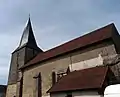 Kirche Saint-Médard
This article is issued from Wikipedia. The text is licensed under Creative Commons - Attribution - Sharealike. The authors of the article are listed here. Additional terms may apply for the media files, click on images to show image meta data.