La Chapelle-Baloue
La Chapelle-Baloue ist eine Gemeinde im Zentralmassiv in Frankreich. Sie gehört zur Region Nouvelle-Aquitaine, zum Département Creuse, zum Arrondissement Guéret und zum Kanton Dun-le-Palestel. Sie grenzt im Norden an Saint-Sébastien, im Nordosten an Crozant, im Südosten an Lafat, im Süden an Saint-Germain-Beaupré (Berührungspunkt) und im Westen an Bazelat.
| La Chapelle-Baloue | ||
|---|---|---|
| ||
| Staat | Frankreich | |
| Region | Nouvelle-Aquitaine | |
| Département (Nr.) | Creuse (23) | |
| Arrondissement | Guéret | |
| Kanton | Dun-le-Palestel | |
| Gemeindeverband | Pays Dunois | |
| Koordinaten | 46° 22′ N, 1° 35′ O | |
| Höhe | 261–381 m | |
| Fläche | 8,64 km² | |
| Einwohner | 128 (1. Januar 2019) | |
| Bevölkerungsdichte | 15 Einw./km² | |
| Postleitzahl | 23160 | |
| INSEE-Code | 23050 | |

Sehenswürdigkeiten
- Flurkreuz, Monument historique
- Kirche Notre-Dame de Lorette, ebenfalls ein Monument historique
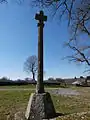 Flurkreuz
_1.JPG.webp) Kirche Notre-Dame de Lorette
Kirche Notre-Dame de Lorette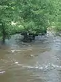 Die Sedelle bei La Chapelle-Balou
Bevölkerungsentwicklung
| Jahr | 1962 | 1968 | 1975 | 1982 | 1990 | 1999 | 2008 | 2013 |
|---|---|---|---|---|---|---|---|---|
| Einwohner | 292 | 264 | 228 | 197 | 151 | 143 | 133 | 138 |
This article is issued from Wikipedia. The text is licensed under Creative Commons - Attribution - Sharealike. The authors of the article are listed here. Additional terms may apply for the media files, click on images to show image meta data.