Peyrabout
Peyrabout ist eine Gemeinde im Zentralmassiv in Frankreich. Sie gehört zur Region Nouvelle-Aquitaine, zum Département Creuse, zum Arrondissement Guéret und zum Kanton Ahun.
| Peyrabout | ||
|---|---|---|
| ||
| Staat | Frankreich | |
| Region | Nouvelle-Aquitaine | |
| Département (Nr.) | Creuse (23) | |
| Arrondissement | Guéret | |
| Kanton | Ahun | |
| Gemeindeverband | Grand Guéret | |
| Koordinaten | 46° 6′ N, 1° 55′ O | |
| Höhe | 446–685 m | |
| Fläche | 8,99 km² | |
| Einwohner | 156 (1. Januar 2019) | |
| Bevölkerungsdichte | 17 Einw./km² | |
| Postleitzahl | 23000 | |
| INSEE-Code | 23150 | |

Lage
Peyrabout grenzt im Norden an Sainte-Feyre, im Nordosten an La Saunière, im Osten an Saint-Yrieix-les-Bois, im Süden an Lépinas, im Südwesten an Maisonnisses und Sardent sowie im Westen an Savennes. Nahe dem Ortsteil Pétillat entspringt die Gartempe.
Bevölkerungsentwicklung
| Jahr | 1962 | 1968 | 1975 | 1982 | 1990 | 1999 | 2008 | 2018 |
|---|---|---|---|---|---|---|---|---|
| Einwohner | 139 | 111 | 114 | 171 | 162 | 158 | 140 | 155 |
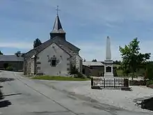
Kirche Sainte-Marie-Madeleine und Gefallenendenkmal
This article is issued from Wikipedia. The text is licensed under Creative Commons - Attribution - Sharealike. The authors of the article are listed here. Additional terms may apply for the media files, click on images to show image meta data.