M 04
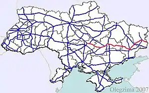
Die M 04 ist eine ukrainische Fernstraße. Sie führt von Snamjanka bei Kropywnyzkyj über Dnipro, Donezk und Luhansk zur russischen Grenze bei Kamensk-Schachtinski. Bis 1991 war die M 04 Teil der M 21 im sowjetischen Fernstraßennetz. Sie bildet einen Abschnitt der E 50.
| Fernstraße M04 in der Ukraine | |
 | |
| | |
| Karte | |
 M 04 | |
| Basisdaten | |
| Betreiber: | |
| Gesamtlänge: | 566,9 km |
%252C_Oblast_Dnipropetrowsk%252C_Ukraine.JPG.webp) | |
| M04 bei Schowte (Rajon Pjatychatky), Oblast Dnipropetrowsk | |
Straßenverlauf | |
Verlauf
- Snamjanka
- Oleksandrija
- Kukoliwka
- Pjatychatky
- Mykolajiwka
- Dnipro
- Nowomoskowsk
- Pawlohrad
- Dmytriwka
- Petropawliwka
- Krasnoarmijsk
- Selydowe
- Donezk
- Makijiwka
- Jenakijewe
- Wuhlehirsk
- Debalzewe
- Tschornuchyne
- Altschewsk
- Luhansk
- Nowoswitliwka
- Krasnodon
- russische Grenze
Internationale: M 01 | M 02 | M 03 | M 04 | M 05 | M 06 | M 07 | M 08 | M 09 | M 10 | M 11 | M 12 | M 13 | M 14 | M 15 | M 16 | M 17 | M 18 | M 19 | M 20 | M 21 | M 22 | M 23 | M 24 | M 25 | M 26 | M 27 | M 28 | M 29
Nationale: N 01 | N 02 | N 03 | N 05 | N 06 | N 07 | N 08 | N 09 | N 10 | N 11 | N 12 | N 13 | N 14 | N 15 | N 16 | N 17 | N 18 | N 19 | N 20 | N 21 | N 22 | N 23 | N 24 | N 25 | N 26 | N 27 | N 28 | N 30 | N 31 | N 32 | N 33
This article is issued from Wikipedia. The text is licensed under Creative Commons - Attribution - Sharealike. The authors of the article are listed here. Additional terms may apply for the media files, click on images to show image meta data.