M 02
Die M 02 ist eine ukrainische Fernstraße. Sie führt von Kipti in östliche Richtung bis zur russisch-ukrainischen Grenze. Sie ist Teil der Straßenverbindung Kiew–Moskau und somit auch der Europastraße 101.
| Fernstraße M02 in der Ukraine | |
 | |
| | |
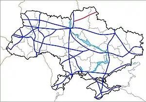
| Karte | |
 M 02 | |
| Basisdaten | |
| Betreiber: | |
| Gesamtlänge: | 242,5 km |
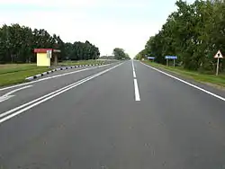 | |
| Die M 02 bei Baturyn | |
Verlauf
| 0 km | Kipti |
| 51 km | Wertijewka (bei Nischyn) |
| 93 km | Borsna |
| 126 km | Baturyn (bei Konotop) |
| 168 km | Krolewez |
| 208 km | Hluchiw |
| russische Grenze, Fortsetzung als M 3 |
Internationale: M 01 | M 02 | M 03 | M 04 | M 05 | M 06 | M 07 | M 08 | M 09 | M 10 | M 11 | M 12 | M 13 | M 14 | M 15 | M 16 | M 17 | M 18 | M 19 | M 20 | M 21 | M 22 | M 23 | M 24 | M 25 | M 26 | M 27 | M 28 | M 29
Nationale: N 01 | N 02 | N 03 | N 05 | N 06 | N 07 | N 08 | N 09 | N 10 | N 11 | N 12 | N 13 | N 14 | N 15 | N 16 | N 17 | N 18 | N 19 | N 20 | N 21 | N 22 | N 23 | N 24 | N 25 | N 26 | N 27 | N 28 | N 30 | N 31 | N 32 | N 33
This article is issued from Wikipedia. The text is licensed under Creative Commons - Attribution - Sharealike. The authors of the article are listed here. Additional terms may apply for the media files, click on images to show image meta data.