Kanton Villedieu-les-Poêles-Rouffigny
Der Kanton Villedieu-les-Poêles-Rouffigny (früher Villedieu-les-Poêles) ist ein französischer Wahlkreis in den Arrondissements Avranches und Saint-Lô, im Département Manche und in der Region Normandie; sein Hauptort ist Villedieu-les-Poêles-Rouffigny, Vertreter im Generalrat des Départements ist seit 1998 (wiedergewählt 2004 und 2011) Jean-Yves Guillou.
| Kanton Villedieu-les-Poêles-Rouffigny | |
|---|---|
| Region | Normandie |
| Département | Manche |
| Arrondissement | Avranches (7 Gemeinden) Saint-Lô (20 Gemeinden) |
| Hauptort | Villedieu-les-Poêles-Rouffigny |
| Einwohner | 15.646 (1. Jan. 2019) |
| Bevölkerungsdichte | 53 Einw./km² |
| Fläche | 296,53 km² |
| Gemeinden | 27 |
| INSEE-Code | 5027 |
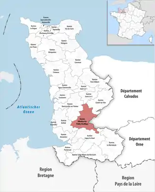 Lage des Kantons Villedieu-les-Poêles-Rouffigny im Département Manche | |
Der Kanton ist 293,93 km² groß und hat (2019) 15.646 Einwohner, was einer Bevölkerungsdichte von 53 Einwohnern pro km² entspricht.
Gemeinden
Der Kanton besteht aus 27 Gemeinden mit insgesamt 15.646 Einwohnern (Stand: 1. Januar 2019) auf einer Gesamtfläche von 296,53 km²:
| Gemeinde | Einwohner 1. Januar 2019 |
Fläche km² |
Dichte Einw./km² |
Code INSEE |
Postleitzahl | Arrondissement |
|---|---|---|---|---|---|---|
| Beslon | 556 | 17,52 | 32 | 50048 | 50800 | Saint-Lô |
| Boisyvon | 116 | 3,88 | 30 | 50062 | 50800 | Avranches |
| Bourguenolles | 345 | 7,73 | 45 | 50069 | 50800 | Saint-Lô |
| Champrepus | 328 | 9,22 | 36 | 50118 | 50800 | Saint-Lô |
| Chérencé-le-Héron | 427 | 9,66 | 44 | 50130 | 50800 | Saint-Lô |
| Coulouvray-Boisbenâtre | 540 | 17,26 | 31 | 50144 | 50670 | Avranches |
| Fleury | 1.045 | 12,80 | 82 | 50185 | 50800 | Saint-Lô |
| La Bloutière | 436 | 9,49 | 46 | 50060 | 50800 | Saint-Lô |
| La Chapelle-Cécelin | 244 | 5,19 | 47 | 50121 | 50800 | Avranches |
| La Colombe | 627 | 14,49 | 43 | 50137 | 50800 | Saint-Lô |
| La Haye-Bellefond | 77 | 2,95 | 26 | 50234 | 50410 | Saint-Lô |
| La Lande-d’Airou | 530 | 15,13 | 35 | 50262 | 50800 | Saint-Lô |
| La Trinité | 391 | 9,16 | 43 | 50607 | 50800 | Saint-Lô |
| Le Guislain | 143 | 5,51 | 26 | 50225 | 50410 | Saint-Lô |
| Le Tanu | 406 | 10,11 | 40 | 50590 | 50320 | Avranches |
| Margueray | 121 | 4,72 | 26 | 50291 | 50410 | Saint-Lô |
| Maupertuis | 143 | 5,46 | 26 | 50295 | 50410 | Saint-Lô |
| Montabot | 276 | 11,66 | 24 | 50334 | 50410 | Saint-Lô |
| Montbray | 299 | 14,29 | 21 | 50338 | 50410 | Saint-Lô |
| Morigny | 72 | 4,39 | 16 | 50357 | 50410 | Saint-Lô |
| Percy-en-Normandie | 2.600 | 48,56 | 54 | 50393 | 50410 | Saint-Lô |
| Saint-Martin-le-Bouillant | 327 | 12,50 | 26 | 50518 | 50800 | Avranches |
| Saint-Maur-des-Bois | 154 | 5,00 | 31 | 50521 | 50800 | Avranches |
| Saint-Pois | 490 | 7,75 | 63 | 50542 | 50670 | Avranches |
| Sainte-Cécile | 785 | 11,57 | 68 | 50453 | 50800 | Saint-Lô |
| Villebaudon | 316 | 5,76 | 55 | 50637 | 50410 | Saint-Lô |
| Villedieu-les-Poêles-Rouffigny | 3.852 | 14,77 | 261 | 50639 | 50800 | Saint-Lô |
| Kanton Villedieu-les-Poêles-Rouffigny | 15.646 | 296,53 | 53 | 5027 | – | – |
Bis zur Neuordnung bestand der Kanton Villedieu-les-Poêles-Rouffigny aus den 10 Gemeinden La Bloutière, Bourguenolles, Champrepus, Chérencé-le-Héron, Fleury, La Lande-d’Airou, Rouffigny, Sainte-Cécile, La Trinité und Villedieu-les-Poêles. Sein Zuschnitt entsprach einer Fläche von 99 km2.
Veränderungen im Gemeindebestand seit der landesweiten Neuordnung der Kantone
2016:
- Fusion Le Chefresne und Percy → Percy-en-Normandie
- Fusion Rouffigny und Villedieu-les-Poêles → Villedieu-les-Poêles-Rouffigny
Bevölkerungsentwicklung
| 1962 | 1968 | 1975 | 1982 | 1990 | 1999 | 2006 |
|---|---|---|---|---|---|---|
| 8 029 | 7 994 | 7 980 | 8 278 | 8 155 | 7 993 | 8 031 |