Kanton Péronne
Der Kanton Péronne ist ein französischer Wahlkreis im Arrondissement Péronne, im Département Somme und in der Region Hauts-de-France; sein Verwaltungssitz ist Péronne. Vertreter im Generalrat des Départements ist seit 1988 Pierre Linéatte (PS).
| Kanton Péronne | |
|---|---|
| Region | Hauts-de-France |
| Département | Somme |
| Arrondissement | Péronne |
| Hauptort | Péronne |
| Einwohner | 27.052 (1. Jan. 2019) |
| Bevölkerungsdichte | 58 Einw./km² |
| Fläche | 466,13 km² |
| Gemeinden | 60 |
| INSEE-Code | 8020 |
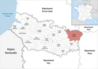 Lage des Kantons Péronne im Département Somme | |
Gemeinden
Der Kanton besteht aus 60 Gemeinden mit insgesamt 27.052 Einwohnern (Stand: 1. Januar 2019) auf einer Gesamtfläche von 466,13 km²:
| Gemeinde | Einwohner 1. Januar 2019 |
Fläche km² |
Dichte Einw./km² |
Code INSEE |
Postleitzahl |
|---|---|---|---|---|---|
| Aizecourt-le-Bas | 56 | 3,55 | 16 | 80014 | 80240 |
| Aizecourt-le-Haut | 64 | 3,72 | 17 | 80015 | 80200 |
| Allaines | 442 | 8,40 | 53 | 80017 | 80200 |
| Barleux | 236 | 7,55 | 31 | 80054 | 80200 |
| Bernes | 353 | 7,67 | 46 | 80088 | 80240 |
| Biaches | 383 | 6,60 | 58 | 80102 | 80200 |
| Bouchavesnes-Bergen | 282 | 10,16 | 28 | 80115 | 80200 |
| Bouvincourt-en-Vermandois | 147 | 1,98 | 74 | 80128 | 80200 |
| Brie | 329 | 6,86 | 48 | 80141 | 80200 |
| Buire-Courcelles | 222 | 7,84 | 28 | 80150 | 80200 |
| Bussu | 213 | 6,92 | 31 | 80154 | 80200 |
| Cartigny | 715 | 15,35 | 47 | 80177 | 80200 |
| Cléry-sur-Somme | 522 | 18,90 | 28 | 80199 | 80200 |
| Combles | 738 | 9,88 | 75 | 80204 | 80360 |
| Devise | 53 | 2,78 | 19 | 80239 | 80200 |
| Doingt | 1.402 | 8,80 | 159 | 80240 | 80200 |
| Driencourt | 87 | 5,05 | 17 | 80258 | 80240 |
| Épehy | 1.129 | 17,39 | 65 | 80271 | 80740 |
| Équancourt | 298 | 7,85 | 38 | 80275 | 80360 |
| Estrées-Mons | 594 | 15,50 | 38 | 80557 | 80200 |
| Éterpigny | 159 | 4,02 | 40 | 80294 | 80200 |
| Étricourt-Manancourt | 529 | 10,95 | 48 | 80298 | 80360 |
| Feuillères | 153 | 5,96 | 26 | 80307 | 80200 |
| Fins | 279 | 6,84 | 41 | 80312 | 80360 |
| Flaucourt | 292 | 7,46 | 39 | 80313 | 80200 |
| Flers | 199 | 6,36 | 31 | 80314 | 80360 |
| Ginchy | 66 | 5,87 | 11 | 80378 | 80360 |
| Gueudecourt | 93 | 4,93 | 19 | 80397 | 80360 |
| Guillemont | 130 | 3,27 | 40 | 80401 | 80360 |
| Guyencourt-Saulcourt | 142 | 5,04 | 28 | 80404 | 80240 |
| Hancourt | 90 | 4,11 | 22 | 80413 | 80240 |
| Hardecourt-aux-Bois | 84 | 5,26 | 16 | 80418 | 80360 |
| Hem-Monacu | 134 | 3,67 | 37 | 80428 | 80360 |
| Hervilly | 190 | 6,29 | 30 | 80434 | 80240 |
| Herbécourt | 201 | 4,43 | 45 | 80430 | 80200 |
| Hesbécourt | 57 | 3,60 | 16 | 80435 | 80240 |
| Heudicourt | 511 | 12,70 | 40 | 80438 | 80122 |
| Lesbœufs | 173 | 6,00 | 29 | 80472 | 80360 |
| Liéramont | 215 | 7,32 | 29 | 80475 | 80240 |
| Longavesnes | 79 | 4,08 | 19 | 80487 | 80240 |
| Longueval | 273 | 8,66 | 32 | 80490 | 80360 |
| Marquaix | 194 | 5,44 | 36 | 80516 | 80240 |
| Maurepas | 211 | 10,89 | 19 | 80521 | 80360 |
| Mesnil-Bruntel | 287 | 7,39 | 39 | 80536 | 80200 |
| Mesnil-en-Arrouaise | 122 | 6,51 | 19 | 80538 | 80360 |
| Moislains | 1.153 | 20,88 | 55 | 80552 | 80200 |
| Nurlu | 373 | 6,74 | 55 | 80601 | 80240 |
| Péronne | 7.577 | 14,19 | 534 | 80620 | 80200 |
| Pœuilly | 108 | 6,16 | 18 | 80629 | 80240 |
| Rancourt | 192 | 2,90 | 66 | 80664 | 80360 |
| Roisel | 1.593 | 10,05 | 159 | 80677 | 80240 |
| Ronssoy | 591 | 7,59 | 78 | 80679 | 80740 |
| Sailly-Saillisel | 483 | 9,43 | 51 | 80695 | 80360 |
| Sorel | 161 | 7,93 | 20 | 80737 | 80240 |
| Templeux-la-Fosse | 136 | 7,33 | 19 | 80747 | 80240 |
| Templeux-le-Guérard | 185 | 6,57 | 28 | 80748 | 80240 |
| Tincourt-Boucly | 346 | 12,93 | 27 | 80762 | 80240 |
| Villers-Carbonnel | 330 | 7,90 | 42 | 80801 | 80200 |
| Villers-Faucon | 557 | 11,48 | 49 | 80802 | 80240 |
| Vraignes-en-Vermandois | 139 | 4,25 | 33 | 80812 | 80240 |
| Kanton Péronne | 27.052 | 466,13 | 58 | 8020 | – |
Bis zur Neuordnung bestand der Kanton Péronne aus den 21 Gemeinden Aizecourt-le-Haut, Allaines, Barleux, Biaches, Bouchavesnes-Bergen, Bouvincourt-en-Vermandois, Brie, Buire-Courcelles, Bussu, Cartigny, Cléry-sur-Somme, Doingt, Éterpigny, Feuillères, Flaucourt, Mesnil-Bruntel, Moislains, Estrées-Mons, Nurlu, Péronne und Villers-Carbonnel. Sein Zuschnitt entsprach einer Fläche von 190,88 km2.