Courson-Monteloup
Courson-Monteloup ist eine französische Gemeinde mit 577 Einwohnern (Stand: 1. Januar 2019) im Département Essonne in der Region Île-de-France. Courson-Monteloup gehört zum Arrondissement Palaiseau und zum Kanton Dourdan (bis 2015: Kanton Limours). Die Einwohner werden Montelupins genannt.
| Courson-Monteloup | ||
|---|---|---|
|
| |
| Staat | Frankreich | |
| Region | Île-de-France | |
| Département (Nr.) | Essonne (91) | |
| Arrondissement | Palaiseau | |
| Kanton | Dourdan | |
| Gemeindeverband | Pays de Limours | |
| Koordinaten | 48° 36′ N, 2° 9′ O | |
| Höhe | 72–104 m | |
| Fläche | 3,78 km² | |
| Einwohner | 577 (1. Januar 2019) | |
| Bevölkerungsdichte | 153 Einw./km² | |
| Postleitzahl | 91680 | |
| INSEE-Code | 91186 | |
| Website | https://www.courson-monteloup.fr/ | |
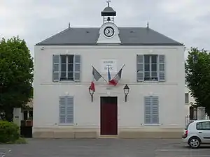 Rathaus von Courson-Monteloup | ||

Geographie
Courson-Monteloup liegt rund 32 Kilometer südsüdwestlich von Paris. Die Gemeinde gehört zum Regionalen Naturpark Haute Vallée de Chevreuse. Umgeben wird Courson-Monteloup von den Nachbargemeinden Briis-sous-Forges im Norden, Fontenay-lès-Briis im Osten, Saint-Maurice-Montcouronne im Süden sowie Vaugrigneuse im Westen.
Bevölkerungsentwicklung
| Jahr | 1962 | 1968 | 1975 | 1982 | 1990 | 1999 | 2006 | 2013 |
| Einwohner | 145 | 146 | 209 | 302 | 461 | 586 | 583 | 604 |
| Quelle: Cassini und INSEE | ||||||||
Sehenswürdigkeiten
Siehe auch: Liste der Monuments historiques in Courson-Monteloup
- Kirche Saint-Claude
- Schloss Courson
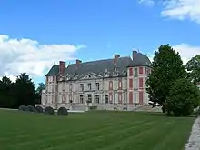
Schloss Courson
Literatur
- Le Patrimoine des Communes de l’Essonne. Flohic Éditions, Band 2, Paris 2001, ISBN 2-84234-126-0, S. 525–527.
This article is issued from Wikipedia. The text is licensed under Creative Commons - Attribution - Sharealike. The authors of the article are listed here. Additional terms may apply for the media files, click on images to show image meta data.