Valletot
Valletot ist eine französische Gemeinde mit 441 Einwohnern (Stand: 1. Januar 2019) im Département Eure in der Region Normandie (vor 2016 Haute-Normandie). Sie gehört zum Arrondissement Bernay und ist Teil des Kantons Bourg-Achard (bis 2015 Routot). Die Einwohner werden Valletotois genannt.
| Valletot | ||
|---|---|---|
| ||
| Staat | Frankreich | |
| Region | Normandie | |
| Département (Nr.) | Eure (27) | |
| Arrondissement | Bernay | |
| Kanton | Bourg-Achard | |
| Gemeindeverband | Roumois Seine | |
| Koordinaten | 49° 22′ N, 0° 37′ O | |
| Höhe | 45–136 m | |
| Fläche | 5,90 km² | |
| Einwohner | 441 (1. Januar 2019) | |
| Bevölkerungsdichte | 75 Einw./km² | |
| Postleitzahl | 27350 | |
| INSEE-Code | 27669 | |

Geographie
Valletot liegt etwa 35 Kilometer westsüdwestlich von Rouen in der Landschaft Roumois. Umgeben wird Valletot von den Nachbargemeinden Bourneville-Sainte-Croix im Norden, Étréville im Osten, Cauverville-en-Roumois im Südosten, Colletot im Süden, Corneville-sur-Risle im Südwesten sowie Le Perrey im Westen und Nordwesten.
Bevölkerungsentwicklung
| Jahr | 1896 | 1926 | 1936 | 1954 | 1962 | 1968 | 1975 | 1982 | 1990 | 1999 | 2006 | 2013 |
| Einwohner | 246 | 207 | 219 | 195 | 209 | 211 | 234 | 216 | 231 | 254 | 301 | 352 |
| Quelle: Cassini und INSEE | ||||||||||||
Sehenswürdigkeiten
- Kirche Saint-Blaise aus dem 12. Jahrhundert, seit 1934 Monument historique
- Schloss Médine
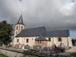
Kirche Saint-Blaise
This article is issued from Wikipedia. The text is licensed under Creative Commons - Attribution - Sharealike. The authors of the article are listed here. Additional terms may apply for the media files, click on images to show image meta data.