Chançay
Chançay ist eine französische Gemeinde mit 1.135 Einwohnern (Stand: 1. Januar 2019) im Département Indre-et-Loire in der Region Centre-Val de Loire; sie gehört zum Arrondissement Tours und zum Kanton Vouvray. Die Einwohner werden Chancéens genannt.
| Chançay | ||
|---|---|---|
.svg.png.webp)
|
| |
| Staat | Frankreich | |
| Region | Centre-Val de Loire | |
| Département (Nr.) | Indre-et-Loire (37) | |
| Arrondissement | Tours | |
| Kanton | Vouvray | |
| Gemeindeverband | Touraine Est Vallées | |
| Koordinaten | 47° 27′ N, 0° 52′ O | |
| Höhe | 54–115 m | |
| Fläche | 15,15 km² | |
| Einwohner | 1.135 (1. Januar 2019) | |
| Bevölkerungsdichte | 75 Einw./km² | |
| Postleitzahl | 37210 | |
| INSEE-Code | 37052 | |
| Website | https://chancay.net | |

Geographie
Chançay liegt etwa fünfzehn Kilometer ostnordöstlich von Tours in der Landschaft Touraine am Fluss Brenne. Umgeben wird Chançay von den Nachbargemeinden Reugny im Norden, Nazelles-Négron im Osten und Südosten, Noizay im Süden sowie Vernou-sur-Brenne im Westen.
Bevölkerungsentwicklung
| Jahr | 1962 | 1968 | 1975 | 1982 | 1990 | 1999 | 2006 | 2017 |
| Einwohner | 615 | 579 | 603 | 814 | 894 | 947 | 1000 | 1137 |
| Quellen: Cassini und INSEE | ||||||||
Sehenswürdigkeiten
- Kirche Saint-Pierre
- Schloss Valmer aus dem 16. Jahrhundert, seit 1930 Monument historique
- Herrenhaus Monfort aus dem 16. Jahrhundert, seit 1947 Monument historique
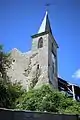 Kirche Saint-Pierre
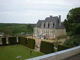 Schloss Valmer
Literatur
- Le Patrimoine des Communes d’Indre-et-Loire. Flohic Editions, Band 2, Paris 2001, ISBN 2-84234-115-5, S. 1367–1369.
Weblinks
Commons: Chançay – Sammlung von Bildern, Videos und Audiodateien
This article is issued from Wikipedia. The text is licensed under Creative Commons - Attribution - Sharealike. The authors of the article are listed here. Additional terms may apply for the media files, click on images to show image meta data.