Biriatou
| Biriatou Biriatu | ||
|---|---|---|
.svg.png.webp)
|
| |
| Staat | Frankreich | |
| Region | Nouvelle-Aquitaine | |
| Département (Nr.) | Pyrénées-Atlantiques (64) | |
| Arrondissement | Bayonne | |
| Kanton | Hendaye-Côte Basque-Sud | |
| Gemeindeverband | Pays Basque | |
| Koordinaten | 43° 20′ N, 1° 45′ W | |
| Höhe | 0–552 m | |
| Fläche | 11,14 km² | |
| Einwohner | 1.228 (1. Januar 2019) | |
| Bevölkerungsdichte | 110 Einw./km² | |
| Postleitzahl | 64700 | |
| INSEE-Code | 64130 | |
| Website | http://www.biriatou.fr/ | |
 Rathaus (Mairie) von Biriatou | ||
Biriatou (baskisch: Biriatu) ist eine Gemeinde im französischen Baskenland mit 1.228 Einwohnern (Stand: 1. Januar 2019) im Département Pyrénées-Atlantiques in der Region Nouvelle-Aquitaine. Sie gehört zum Arrondissement Bayonne, zum Kanton Hendaye-Côte Basque-Sud (bis 2015: Kanton Hendaye) und zum Gemeindeverband Agglomération du Pays Basque. Die Einwohner werden Biriatuar genannt.
Geografie
Biriatou liegt etwa 25 Kilometer südwestlich von Bayonne im Süden der historischen Provinz Labourd in den westlichen Pyrenäen an der Grenze zu Spanien. Umgeben wird Biriatou von den Nachbargemeinden Urrugne im Norden und Osten, Bera im Süden und Südosten sowie Irun im Westen.
Durch die Gemeinde führt die Autoroute A63.
Einwohnerentwicklung
| Jahr | 1962 | 1968 | 1975 | 1982 | 1990 | 1999 | 2006 | 2013 |
| Einwohner | 545 | 577 | 530 | 594 | 694 | 831 | 952 | 1.167 |
| Quelle: Cassini und INSEE | ||||||||
Sehenswürdigkeiten

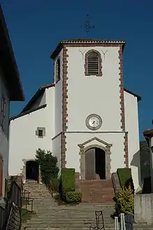
Kirche Saint-Martin
- Kirche Saint-Martin aus dem 16. Jahrhundert, Monument historique
- baskische Stelen
Weblinks
Commons: Biriatou – Sammlung von Bildern, Videos und Audiodateien
This article is issued from Wikipedia. The text is licensed under Creative Commons - Attribution - Sharealike. The authors of the article are listed here. Additional terms may apply for the media files, click on images to show image meta data.
