Yolet
Yolet ist eine französische Gemeinde im Département Cantal in der Region Auvergne-Rhône-Alpes. Sie gehört zum Kanton Vic-sur-Cère (bis 2015 Kanton Aurillac-4) im Arrondissement Aurillac. Sie grenzt im Westen und im Nordwesten an Giou-de-Mamou, im Nordosten und im Osten an Polminhac und im Süden an Vézac. Zu Yolet gehören auch die Ortsteile Le Bourg, Falguières am Bach Ruisseau de Giou, Gare de Yolet, Lalo, Maison-Blanche, Rocquecelier und Sémilhac. Die Route nationale 126 führt über Yolet.
| Yolet | ||
|---|---|---|
| ||
| Staat | Frankreich | |
| Region | Auvergne-Rhône-Alpes | |
| Département (Nr.) | Cantal (15) | |
| Arrondissement | Aurillac | |
| Kanton | Vic-sur-Cère | |
| Gemeindeverband | Bassin d’Aurillac | |
| Koordinaten | 44° 56′ N, 2° 32′ O | |
| Höhe | 616–969 m | |
| Fläche | 9,87 km² | |
| Einwohner | 551 (1. Januar 2019) | |
| Bevölkerungsdichte | 56 Einw./km² | |
| Postleitzahl | 15130 | |
| INSEE-Code | 15266 | |

Bevölkerungsentwicklung
| Jahr | 1962 | 1968 | 1975 | 1982 | 1990 | 1999 | 2006 | 2013 | |
|---|---|---|---|---|---|---|---|---|---|
| Einwohner | 440 | 420 | 383 | 381 | 459 | 488 | 577 | 563 | |
| Quellen: Cassini und INSEE | |||||||||
Sehenswürdigkeiten
- Kirche Saint-Pierre, erbaut im 14./15. Jahrhundert, seit 1992 Monument historique
- Schlösser Château de Boudieu, Château du Doux und Château de Yolet
.jpg.webp) Kirche Saint-Pierre
Kirche Saint-Pierre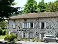 Mairie Yolet
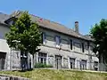 Schule
Persönlichkeiten
- Jean-Baptiste Carrier, Revolutionär
This article is issued from Wikipedia. The text is licensed under Creative Commons - Attribution - Sharealike. The authors of the article are listed here. Additional terms may apply for the media files, click on images to show image meta data.