Le Trioulou
Le Trioulou ist eine französische Gemeinde mit 101 Einwohnern (Stand: 1. Januar 2019) im Département Cantal in der Region Auvergne-Rhône-Alpes. Sie gehört zum Arrondissement Aurillac und ist Teil des Kantons Maurs.
| Le Trioulou | ||
|---|---|---|
| ||
| Staat | Frankreich | |
| Region | Auvergne-Rhône-Alpes | |
| Département (Nr.) | Cantal (15) | |
| Arrondissement | Aurillac | |
| Kanton | Maurs | |
| Gemeindeverband | Châtaigneraie Cantalienne | |
| Koordinaten | 44° 11′ N, 2° 20′ O | |
| Höhe | 234–403 m | |
| Fläche | 6,04 km² | |
| Einwohner | 101 (1. Januar 2019) | |
| Bevölkerungsdichte | 17 Einw./km² | |
| Postleitzahl | 15600 | |
| INSEE-Code | 15242 | |
| Website | http://mairie.pagespro-orange.fr/mairiedutrioulou/ | |

Lage
Le Trioulou liegt im Zentralmassiv, etwa 29 Kilometer südwestlich von Aurillac. Umgeben wird Le Trioulou von den Nachbargemeinden Maurs im Norden, Saint-Constant-Fournoulès im Osten, Saint-Santin-de-Maurs im Süden sowie Bagnac-sur-Célé im Westen.
Bevölkerungsentwicklung
| Jahr | 1962 | 1968 | 1975 | 1982 | 1990 | 1999 | 2006 | 2011 | 2016 |
| Einwohner | 205 | 191 | 165 | 138 | 127 | 99 | 95 | 94 | 106 |
| Quellen: Cassini und INSEE | |||||||||
Sehenswürdigkeiten
- Kirche Saint-Blaise
- Schloss
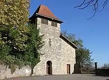
Kirche Saint-Blaise
This article is issued from Wikipedia. The text is licensed under Creative Commons - Attribution - Sharealike. The authors of the article are listed here. Additional terms may apply for the media files, click on images to show image meta data.