Saint-Georges-de-Longuepierre
Saint-Georges-de-Longuepierre ist eine französische Gemeinde mit 223 Einwohnern (Stand: 1. Januar 2019) im Département Charente-Maritime in der Region Nouvelle-Aquitaine (vor 2016: Poitou-Charentes); sie gehört zum Arrondissement Saint-Jean-d’Angély und ist Teil des Kantons Matha (bis 2015: Kanton Aulnay). Die Einwohner werden Saint-Georgeais genannt.
| Saint-Georges-de-Longuepierre | ||
|---|---|---|
| ||
| Staat | Frankreich | |
| Region | Nouvelle-Aquitaine | |
| Département (Nr.) | Charente-Maritime (17) | |
| Arrondissement | Saint-Jean-d’Angély | |
| Kanton | Matha | |
| Gemeindeverband | Vals de Saintonge | |
| Koordinaten | 46° 3′ N, 0° 24′ W | |
| Höhe | 25–82 m | |
| Fläche | 10,65 km² | |
| Einwohner | 223 (1. Januar 2019) | |
| Bevölkerungsdichte | 21 Einw./km² | |
| Postleitzahl | 17470 | |
| INSEE-Code | 17334 | |
| Website | http://www.saint-georges-de-longuepierre.fr/ | |
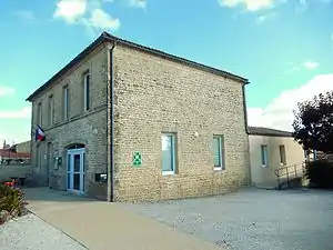 Rathaus (Mairie) von Saint-Georges-de-Longuepierre | ||

Geographie
Saint-Georges-de-Longuepierre liegt etwa 62 Kilometer ostsüdöstlich von La Rochelle in der Saintonge. Umgeben wird Saint-Georges-de-Longuepierre von den Nachbargemeinden Dampierre-sur-Boutonne im Norden, Aulnay im Osten, Nuaillé-sur-Boutonne im Süden, Saint-Pierre-de-l’Isle im Südwesten sowie Blanzay-sur-Boutonne im Westen.
Bevölkerungsentwicklung
| Jahr | 1962 | 1968 | 1975 | 1982 | 1990 | 1999 | 2006 | 2013 |
| Einwohner | 288 | 259 | 232 | 230 | 205 | 217 | 223 | 259 |
| Quelle: Cassini und INSEE | ||||||||
Sehenswürdigkeiten
- Kirche Saint-Georges aus dem 19. Jahrhundert

Kirche Saint-Georges
Literatur
- Le Patrimoine des Communes de la Charente-Maritime. Flohic Editions, Band 1, Paris 2002, ISBN 2-84234-129-5, S. 134–135.
This article is issued from Wikipedia. The text is licensed under Creative Commons - Attribution - Sharealike. The authors of the article are listed here. Additional terms may apply for the media files, click on images to show image meta data.