Torxé
Torxé ist eine französische Gemeinde mit 230 Einwohnern (Stand: 1. Januar 2019) im Département Charente-Maritime in der Region Nouvelle-Aquitaine (vor 2016: Poitou-Charentes); sie gehört zum Arrondissement Saint-Jean-d’Angély und ist Teil des Kantons Saint-Jean-d’Angély (bis 2015: Kanton Tonnay-Boutonne). Die Einwohner werden Torxéens genannt.
| Torxé | ||
|---|---|---|
| ||
| Staat | Frankreich | |
| Region | Nouvelle-Aquitaine | |
| Département (Nr.) | Charente-Maritime (17) | |
| Arrondissement | Saint-Jean-d’Angély | |
| Kanton | Saint-Jean-d’Angély | |
| Gemeindeverband | Vals de Saintonge | |
| Koordinaten | 45° 57′ N, 0° 38′ W | |
| Höhe | 2–63 m | |
| Fläche | 11,49 km² | |
| Einwohner | 230 (1. Januar 2019) | |
| Bevölkerungsdichte | 20 Einw./km² | |
| Postleitzahl | 17380 | |
| INSEE-Code | 17450 | |
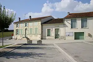 Rathaus (Mairie) von Torxé | ||

Geographie
Torxé liegt etwa 50 Kilometer ostsüdöstlich von La Rochelle. Umgeben wird Torxé von den Nachbargemeinden Puyrolland und Nachamps im Norden, Landes im Osten, Chantemerle-sur-le-Soie im Süden sowie Tonnay-Boutonne im Westen.
Bevölkerungsentwicklung
| Jahr | 1962 | 1968 | 1975 | 1982 | 1990 | 1999 | 2006 | 2013 |
| Einwohner | 307 | 272 | 244 | 216 | 202 | 233 | 231 | 231 |
| Quelle: Cassini und INSEE | ||||||||
Sehenswürdigkeiten
- Kirche Saint-Pierre aus dem 13. Jahrhundert
- Mühle von Saint-Marmé
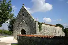
Kirche Saint-Pierre
Literatur
- Le Patrimoine des Communes de la Charente-Maritime. Flohic Editions, Band 2, Paris 2002, ISBN 2-84234-129-5, S. 1115–1116.
This article is issued from Wikipedia. The text is licensed under Creative Commons - Attribution - Sharealike. The authors of the article are listed here. Additional terms may apply for the media files, click on images to show image meta data.