Coivert
Coivert ist eine französische Gemeinde mit 212 Einwohnern (Stand: 1. Januar 2019) im Département Charente-Maritime in der Region Nouvelle-Aquitaine (vor 2016: Poitou-Charentes); sie gehört zum Arrondissement Saint-Jean-d’Angély und ist Teil des Kantons Matha (bis 2015: Kanton Loulay). Die Einwohner werden Coivertains genannt.
| Coivert | ||
|---|---|---|
| ||
| Staat | Frankreich | |
| Region | Nouvelle-Aquitaine | |
| Département (Nr.) | Charente-Maritime (17) | |
| Arrondissement | Saint-Jean-d’Angély | |
| Kanton | Matha | |
| Gemeindeverband | Vals de Saintonge | |
| Koordinaten | 46° 4′ N, 0° 27′ W | |
| Höhe | 27–81 m | |
| Fläche | 15,00 km² | |
| Einwohner | 212 (1. Januar 2019) | |
| Bevölkerungsdichte | 14 Einw./km² | |
| Postleitzahl | 17330 | |
| INSEE-Code | 17114 | |
 Rathaus (Mairie) von Coivert | ||

Geographie
Coivert liegt etwa 75 Kilometer ostsüdöstlich von La Rochelle in der Saintonge. Umgeben wird Coivert von den Nachbargemeinden Villeneuve-la-Comtesse im Norden, Saint-Séverin-sur-Boutonne im Nordosten, Dampierre-sur-Boutonne im Osten, Blanzay-sur-Boutonne im Osten und Südosten, Saint-Martial und La Jarrie-Audouin im Süden, Vergné im Westen sowie La Croix-Comtesse im Nordwesten.
Bevölkerungsentwicklung
| Jahr | 1962 | 1968 | 1975 | 1982 | 1990 | 1999 | 2006 | 2013 |
| Einwohner | 310 | 275 | 249 | 245 | 222 | 219 | 228 | 234 |
| Quelle: Cassini und INSEE | ||||||||
Sehenswürdigkeiten
- Kirche Saint-Vivien (siehe auch: Liste der Monuments historiques in Coivert)
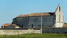
Kirche Saint-Vivien
Literatur
- Le Patrimoine des Communes de la Charente-Maritime. Flohic Editions, Band 1, Paris 2002, ISBN 2-84234-129-5, S. 338–340.
This article is issued from Wikipedia. The text is licensed under Creative Commons - Attribution - Sharealike. The authors of the article are listed here. Additional terms may apply for the media files, click on images to show image meta data.