Vandières (Marne)
Vandières ist eine französische Gemeinde mit 298 Einwohnern (Stand 1. Januar 2019) im Département Marne in der Region Grand Est. Sie gehört zum Arrondissement Reims und zum Kanton Dormans-Paysages de Champagne. Die Gemeinde liegt im Regionalen Naturpark Montagne de Reims.
| Vandières | ||
|---|---|---|
| ||
| Staat | Frankreich | |
| Region | Grand Est | |
| Département (Nr.) | Marne (51) | |
| Arrondissement | Reims | |
| Kanton | Dormans-Paysages de Champagne | |
| Gemeindeverband | Ardre et Châtillonnais | |
| Koordinaten | 49° 7′ N, 3° 44′ O | |
| Höhe | 63–236 m | |
| Fläche | 13,15 km² | |
| Einwohner | 298 (1. Januar 2019) | |
| Bevölkerungsdichte | 23 Einw./km² | |
| Postleitzahl | 51700 | |
| INSEE-Code | 51592 | |
 Mairie Vandières | ||
Geografie
Die Gemeinde Vandières liegt am rechten Ufer der Marne, etwa 20 Kilometer westnordwestlich von Épernay. Umgeben wird Vandières von den Nachbargemeinden Anthenay im Norden, Cuisles im Nordosten, Châtillon-sur-Marne im Osten, Mareuil-le-Port und Troissy im Süden, Verneuil im Südwesten sowie Passy-Grigny im Westen.
Bevölkerungsentwicklung
| Jahr | 1962 | 1968 | 1975 | 1982 | 1990 | 1999 | 2008 | 2018 |
| Einwohner | 372 | 375 | 331 | 329 | 340 | 321 | 333 | 303 |
 Kirche Saint-Martin |
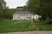
 Schloss Vandières |
This article is issued from Wikipedia. The text is licensed under Creative Commons - Attribution - Sharealike. The authors of the article are listed here. Additional terms may apply for the media files, click on images to show image meta data.
