Villers-Franqueux
Villers-Franqueux ist eine französische Gemeinde mit 296 Einwohnern (Stand: 1. Januar 2019) im Département Marne in der Region Grand Est. Sie gehört zum Arrondissement Reims und zum Kanton Bourgogne.
| Villers-Franqueux | ||
|---|---|---|
| ||
| Staat | Frankreich | |
| Region | Grand Est | |
| Département (Nr.) | Marne (51) | |
| Arrondissement | Reims | |
| Kanton | Bourgogne | |
| Gemeindeverband | Grand Reims | |
| Koordinaten | 49° 20′ N, 3° 57′ O | |
| Höhe | 83–188 m | |
| Fläche | 3,24 km² | |
| Einwohner | 296 (1. Januar 2019) | |
| Bevölkerungsdichte | 91 Einw./km² | |
| Postleitzahl | 51220 | |
| INSEE-Code | 51633 | |
 Rathaus (Mairie) von Villers-Franqueux | ||

Geographie
Villers-Franqueux liegt etwa zwölf Kilometer nordnordwestlich von Reims. Umgeben wird Villers-Franqueux von den Nachbargemeinden Hermonville im Norden und Westen, Loivre im Osten und Nordosten, Thil im Süden und Südosten sowie Pouillon im Süden.
Bevölkerungsentwicklung
| Jahr | 1962 | 1968 | 1975 | 1982 | 1990 | 1999 | 2006 | 2018 |
| Einwohner | 212 | 198 | 228 | 220 | 270 | 281 | 297 | 296 |
| Quellen: Cassini und INSEE | ||||||||
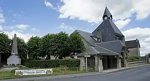
Sehenswürdigkeiten
- Kirche Saint-Théodulphe
.JPG.webp)
Kirche Saint-Théodulphe
This article is issued from Wikipedia. The text is licensed under Creative Commons - Attribution - Sharealike. The authors of the article are listed here. Additional terms may apply for the media files, click on images to show image meta data.